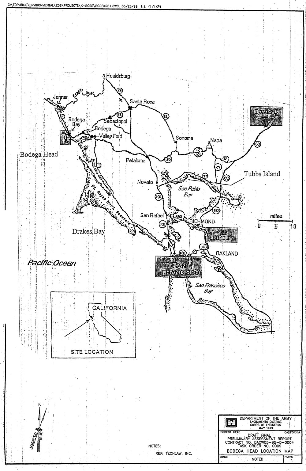
Location
currently part of the Sonoma Coast State Beach and is surrounded by th.e. Pacific Ocean on the west, and Bodega Bay and Bodega Harbor on the east. See Figure 2 for the layout of Bodega Head and the neighboring properties.
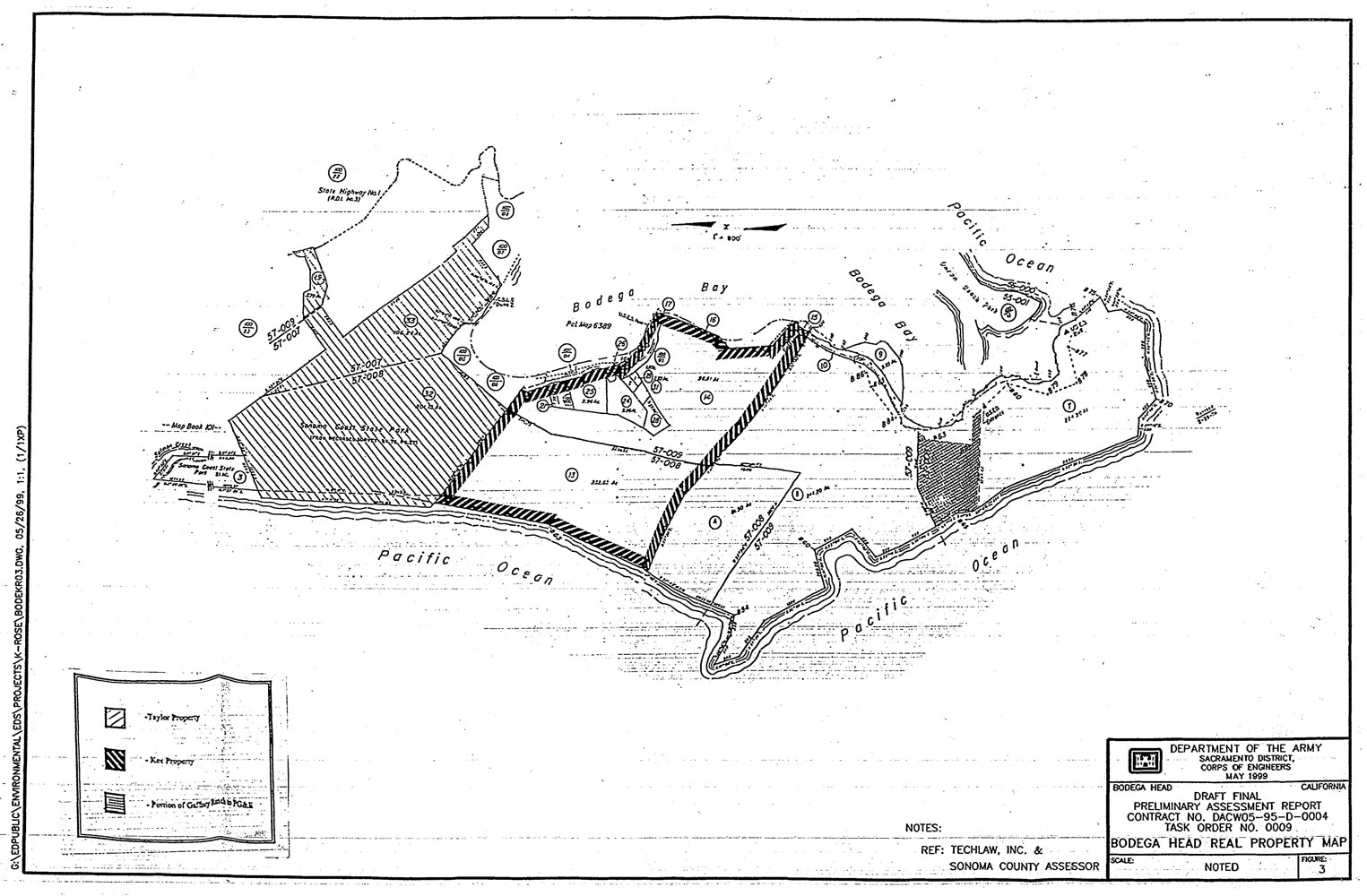
Ownership: Figure 3 is a composite of the two Sonoma County Assessor Maps (100-010 and 100-020) that depict Bodega Head and adjacent properties. Assessor parcel numbers (APNs) are assigned to each property, and consist of the book and page of the map and the individual parcel number (e.g., 100-010-009). Parcel numbers are circled on the map and appear as one or two digit numbers (e.g., 7 for 007, 14 for 014). For the remainder of this report, the properties at and adjacent to Bodega Head will be referred to by their individual one or two digit Parcel number.
From the 1800s until 1957, the Bodega Headlands were owned by two families. The Suoh-Campbell family owned Campbell Cove and the southern end of the head. The Rose Gaffbey family owned the rest of the head, along with a stretch of sand dune peninsula that connects it to the mainland (Kelleher, pg 260-261). In October of 1958, the Pacific Gas and Electric Company (PG&E) filed a suit in Sonoma County Superior Court to acquire the southernmost portion of the 400-acre Rose Gaffney property for the purpose of building an atomic reactor at Horseshoe Cove.
The company eventually decided to build the reactor at Campbell Cove instead, and th.us began pursuing the 160-acre Stroh-Campbell property (Kelleher, pg 262). The deed conveying the
Campbell property (majority of Parcel 7) to PG&E was filed by the end of 1959. The southernmost portion of the Rose Gaffney property (northern one-third of Parcel 7) was also conveyed to PG&E by Deed of Condemnation (Kelleher, pg 263).
PG&E executed a Corporation Grant Deed on November 26, 1973 that conveyed all of Parcel 7 to the State of California after abandoning all plans of building the atomic reactor power plant
(Sonoma County Clerk, 1973). Two other portions of the former Rose Gafhey property, specifically Parcels 8 and 10, were acquired by the Regents of the University of California by Final Order of Condemnation on December 3, 1962 (Sonoma County Clerk, 1962). It is unclear if Parcel 9 was also acquired in the condemnation. On October 26, 1962, Parcel 4 was obtained by the State of California as a result of Final Order of Condemnation to expand the Sonoma Coast State Beach. The State then acquired Parcel 13 as a result of Final Order of Condemnation on October 28, 1963 to again expand the Sonoma Coast State Beach (Sonoma County Clerk, 1963).
Previously, Parcels 19, 32, and 33 had been obtained by the State of California for State Beach purposes by deed on November 7, 1934 (Sonoma County Clerk, 1934).
Army Operations: Several communications occurred in late 1945 and early 1946 between the Headquarters Fourth Air Force, in San Francisco, California, and the Commanding General, Continental Air Forces, at Bolling Field, Washington, D.C. Those communications indicate that the Bodega Head Gunnery Range was an auxiliary facility to Santa Rosa Army Air Field (SRAAF) during World War II, and was desired for possible use by aircraft fiom Hamilton Field for postwar operations (AAF, 1946). Although the Bodega Head Gunnery Range is listed as a training site, no specific location is provided in the documentation.
After the Japanese bombing of Pearl Harbor, troops were dispersed throughout the Pacific Coast. In January of 1942, Troop C of the 107th Cavalry was detailed to Coast Watch at Bodega Bay (LeBaron, pg 289, 1993). Glenice Carpenter, Bodega Bay Historical Society, stated that the Army occupied a ranch house at Bodega Head when the war broke out. According to Ms. Carpenter, the Army kept tanks, vehicles, and other equipment at a "CCC" camp a few miles east of Freestone, California and they drove the tanks out to the dunes at Bodega Head for maneuvers and target practice (CalEPA, 1998).
As the war progressed, battle-fatigued aircraft were returned to the states to be used for pilot training, and accidents occurred frequently. A mid-air collision near Bodega Head was recorded on January 25,1944, involving two planes from the 444th Fighter Squadron SRAAF. It was reported that the collision occurred while the planes were in an aerial gunnery pattern over the Pacific in the area of Bodega Head (Historical Diary, 1/25/44-1/27/44). On July 14, 1944, a Navy Curtiss SB2C "Helldiver" crashed at Bodega Bay. The newspaper headline read "Dive-Bomber Hits Coast Hilltop in Training Maneuvers". The story indicated that four planes were involved in training maneuvers and one of them hit the hilltop after flying through a cloud. There may have been a second crash of a Navy plane near Bodega Head during July (Lebaron, 1993). Although the reports of these incidents are not specific as to the type or location of the training that was taking place, they do provide some insight into the Army's use of the area around Bodega Head.
A 1993 United States Amy Corps of Engineers (USACE) report, prepared by the Huntsville Design Center regarding operations at the former Santa Rosa Army Airfield, indicates that Bodega Head was an area where aerial spraying training was conducted. As part of the chemical warfare training conducted a& S W , pi lots were kained in aerial chemical procedures. These involved spray missions using airplane smoke tanks filled with FS (a screening smoke made with a sulfur trioxide-chlorosulfonic acid solution) or CNB (a tear gas agent consisting of hloroacetophenone_ c; in benzene and carbon tetrachloride). One-hundred fifty hours of chemical training was required for each pilot, and each trainee was required to fly four chemical spray missions (USACE, 1993).
According to a History of the Santa Rosa Amy Air Field, a "Sight Burst Panel was erected at the Bodega Head Gunnery Range to aid in assessment of Gun Camera film" (History of SRAAF,
11/45-3/45). Inferring from several descriptions given by military personnel, a Sight Burst Panel is thought to be a large panel, usually made of fiberglass, that is propped up on one end so that when viewed in profile it intersects the ground at some vertical angle. When the guns of an aircraft are fired at the panel, they punch holes through the thin material. A camera was mounted on the wing of the firing aircraft, adjacent to the guns, and recorded the number and location of the shots that hit the panel.
However, by March 1, 1946, SRAAF and its auxiliary facilities, including the Bodega Head Gunnery Range, were all declared surplus. The National Archives in Washington, D.C. contains documentation that in the late 1950s the Sonoma County Tidelands, Harbor, and Beach Commission submitted a request to the Twelfth U.S. Coat Guard District for the transfer of the Coast Guard Station at Point Reyes, California to Bodega Bay. A letter sent in December, 1958 outlines the need for a Coast Guard Station at Bodega Bay based upon the increase of commercial crabbing and salmon fishing and a plan to institute recreational boating. The letter indicates that a hearing was held on December 11, 1958 regarding the request (Sonoma County Tidelands, 12/4/58). A letter sent in February of 1959 indicates that an additional hearing was held on February 12,1959 in the matter of a Coast Guard Station at Bodega Bay, and it was determined that a lifeboat station was required at Bodega Bay (12& Coast Guard Dist., 2/11/59). There is currently a U.S. Coast Guard Station located on the north side of Dorm Beach in Bodega Harbor (see Figure 2).
The Regents of the University of California used land obtained from Rose Gaffney in the early 1960s to construct the Bodega Marine Life Refuge and U.C. Marine Life Laboratory at Bodega Bay (Sonoma County Clerk, 12/10/62). The Marine Laboratory and Marine Refuge are still in operation at Bodega Head. California State Parks designated the land that was obtained in the mid 1970s from Rose Gaffney, PG&E, and others for recreational use and preservation through the state parks system and state beaches (see Figure 3). The majority of the property at Bodega Head and surrounding
regarding extensive bombing and straf~ngtr aining in Northern California. While previous record searches have provided scant evidence of OE, development has encroached on these former target areas, and occasionally ordnance has been found. The State of California has often expressed safety concerns over these former targets.
TechLaw Inc., a firm hired by the U.S. Army Corps of Engineers (USACE) to research various Formerly Used Defense Sites (FUTDS), located several memoranda dated in late 1945 and early 1946 between Headquarters, Fourth Air Force, in San Francisco, California and the Commanding General, Continental Air Forces, at Bolling Field, Washington D.C., indicating that the Bodega Bay Gunnery Range was an auxiliary facility to Santa Rosa Army Air Field (SRAAF) during World War II and that the gunnery range at the Bodega Bay location was desired for possible use by aircraft from Hamilton Field, Marin County, CA, for post-war operations. According to Mr. Harrison Rued, a representative from the Redwood Empire Aviation Historical Society, the U.S. Army used Bodega Head as a small bombing range for smoke bombs from 1944 to 1945. A midair collision near Bodega Point was recorded on January 25, 1944, involving two planes from the 4441h Fighter Squadron at SRAAF. It was reported to have occurred while the planes were in an aerial gunnery pattern over the Pacific near Bodega Point. In another incident, an SB2C crashed into a hilltop after flying through a cloud at Bodega Bay on July 14, 1944. The crash occurred during regular training maneuvers with three other SB2C's. Although the reports of these incidents do not specify the type or the location of the training that took place, they do support the U.S. Army's use of the area at Bodega Head. A 1993 USACE report, prepared by the Huntsde Design Center regarding operations at the former Santa Rosa Army Airfield, indicated that aerial chemical spray training was conducted at Bodega Head. Those training missions used airplane smoke tanks med with FS (a screening smoke made with sulfur trioxide-chlorosulfonic acid solution) or CNB (a tear gas agent consisting of chloroacetophenone in benzene and carbon tetrachloride). Additionally, the History of the SRAAF, January 1, 1945 through March 31, 1945, reported that a "Sight Burst Panel" was erected at Bodega Head to aid in assessment of Gun Camera Film.
On January 3, 1946, a request was made in a memorandum between Headquarters, Fourth Air Force, and the Commanding General, Continental Air Forces for additional information for "jusuflcation of transfer of ... Bodega Bay Gunnery Range fkom SRAAF to Hamilton Field." A memo dated February 14,1946, indicated that Bodega Bay Gunnery Range should be declared surplus. On March 1,1946, SRAAF and its auxiliary facilities, including.Bodega Bay Gunnery Range, were declared surplus, and the leases for an unspecified acreage of land were canceled and the land was returned to its original owners, the Stroh-Campbell family and the Rose Gaffhey family.