Boron Air Force Station is a closed United
States Air Force General Surveillance Radar station. It is located
6.8 miles (10.9 km) northeast of Boron, California. It was closed
by the Air Force in 1975 and turned over to the Federal Aviation
Administration (FAA). The radar site is still operated by the
FAA as part of the Joint Surveillance System (JSS).
Boron Air Force Station was one of twenty-eight
stations built as part of the second segment of the Air Defense
Command permanent radar network. Prompted by the start of the
Korean War, on July 11, 1950, the Secretary of the Air Force
asked the Secretary of Defense for approval to expedite construction
of the permanent network. Receiving the Defense Secretary’s
approval on July 21, the Air Force directed the Corps of Engineers
to proceed with construction.
The 750th Aircraft Control and Warning
Squadron was assigned to Atolia, California on 28 January 1952.
It assumed coverage responsibilities formerly held by the temporary
"Lashup" site at Edwards AFB site (L-40), and was operating
two AN/FPS-10 radars at this new site, and initially the station
functioned as a Ground-Control Intercept (GCI) and warning station.
As a GCI station, the squadron's role was to guide interceptor
aircraft toward unidentified intruders picked up on the unit's
radar scopes. Atolia AFS was renamed "Boron Air Force Station"
on 1 December 1953.
The AN/FPS-10 search radar at Boron remained
until 1959. In 1958 an AN/FPS-6 replaced the AN/FPS-10 height-finder
radar. A second height-finder radar (AN/FPS-6A) was installed
in 1959.
During 1961 Boron AFS joined the Semi
Automatic Ground Environment (SAGE) system, feeding data to DC-17
at Norton AFB, California. After joining, the squadron was redesignated
as the 750th Radar Squadron (SAGE) on 1 May 1961. The radar squadron
provided information 24/7 the SAGE Direction Center where it
was analyzed to determine range, direction altitude speed and
whether or not aircraft were friendly or hostile.
In addition, Boron AFS became a joint-use
facility with the Federal Aviation Administration (FAA). By this
time the AN/FPS-10 had been replaced by an AN/FPS-20 search radar.
However, this radar was soon replaced by an AN/FPS-35 FD radar.
By 1963 this radar operated with AN/FPS-26A and AN/FPS-90 height-finder
radars. Boron AFS was re-designated as NORAD ID Z-59 on 31 July
1963.
In 1968 the AN/FPS-90 was inactivated.
In 1969 the AN/FPS-35 was removed, and was replaced by an AN/FPS-67
on the same tower (and with a radome); it became operational
in 1970.
In addition to the main facility, Boron
operated several AN/FPS-14 Gap Filler Annexes:
Shafter, CA (P-59A)
Joshua Tree, CA (P-76F), (P-59C)
An Gap Filler Annex (P-59B) was planned
for Lone Pine, CA but never built
Over the years, the equipment at the station was upgraded or
modified to improve the efficiency and accuracy of the information
gathered by the radars. The 750th Radar Squadron was inactivated
on 30 June 1975. The FAA retained the AN/FPS-67, and continue
to operate it today and is now data-tied into the Joint Surveillance
System (JSS).
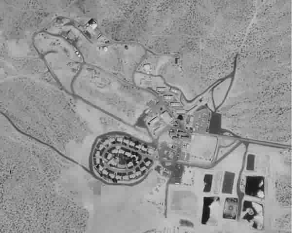
Boron AFS was later converted into a Federal
Prison in 1979, for minimum security male inmates, which was
closed in 2000. The site is now abandoned and being vandalized.
It may eventually be sold as surplus property through the GSA.
Air Force units
Constituted as the 750th Aircraft Control
and Warning Squadron
Activated at Edwards AFB, California on
8 October 1950
Moved to Atolia, California on 28 January
1952
Site redesignated Boron Air Force Station,
1 December 1953
Redesignated 750th Radar Squadron (SAGE)
on 1 May 1961
Redesignated 750th Radar Squadron on 1
February 1974
Inactivated on 30 June 1975
Assignments
544th Aircraft Control and Warning Group,
1 January 1952
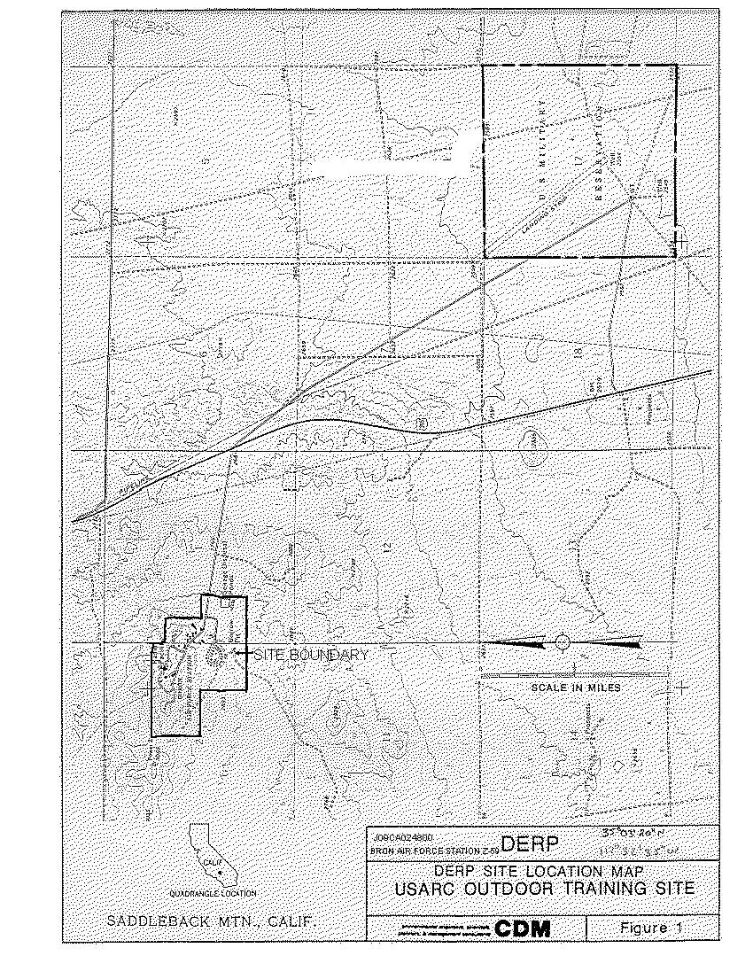
LOCATION: Off of U.S. Highway 395, approximately
10 miles northeast of Boron and 35 miles northwest of Barstow,
San Bernardino County, California.
SITE HISTORY: The Boron Air Force Station Z-59 was acquired by
the United States Air Force in various transactions from 1950
- 1952. Part of the site is presently being used as a federal
prison camp under jurisdiction of the U.S. Department of Justice,
and part is owned by the California State Department of Fish and
Game. The radar tower, generator building, entry road from the
highway, and associated support equipment were transferred to
the Federal Aviation Administration for their use. The 640-acre
portion of land to the southeast was temporarily transferred,
in 1963, to the U.S. Army Reserve for use as an outdoor training
site (DERP Project No. J09CA066400). The land reverted back to
the Air Force in 1967. The California state Department of Fish
and Game later acquired the 640-acre tract for use as a wildlife
refuge in 1978.
Source US Army Corps of Engineers,
Los Angeles District