The History of the 4th AA Command lists a Radar Station B-74 as being located at Fort Bragg. For security reasons, the site was also known as Fort Bragg Defenseive Position, Harbor Defenses of San Francisco. The site was initally garrisoned by the 656th Signal Aircraft Warning Company and followed on by a detachment of the 653rd Signal Aircraft Warning Company. Radar Stations during this period of Army Air Forces control would have been assigned to the 411th Army Air Forces Base Unit (San Francisco Control Group) in Berkeley, CA.
The site ws equipped with an SCR-271 radar set. It is not known if this set was a "D" or "E" variant.
In the 20 March 1946 document titled Detailed Plan for the Retrenchment of Fourth Air Force Control Group Installation, the Chief, Control Group Division, Fourth Air Force recommended that this site be removed. Assigned to the San Francisco Control Group.
Concerning the location of said radar station, when querying Mr. Bud d'Arezzo of the Fort Bragg-Mendocino Coast Historical Society, the only Army installation they know of in the immediate vicinity was on Bald Hill, just northeast of the city of Fort Bragg. This site is the highest point in the area and is used as a microwave site and a transmitter site for local radio stations. This site is consistent with the deployment of radar equipment of the period. However, this information though is purely anecdotal and should be more fully investigated.
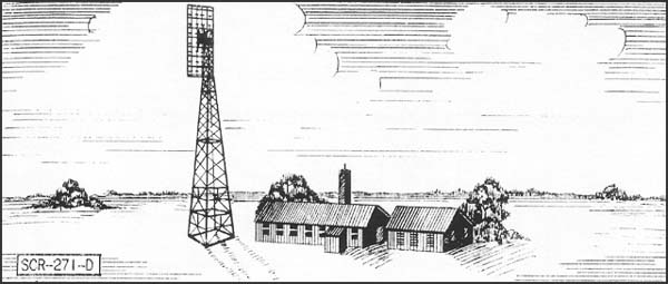
DESCRIPTION: Fixed long wave early warning aircraft detector. Azimuth and range supplied on "A" scopes. 271-D has a 100' tower; 271-E, a 50' tower.
USES: To establish a screen of warning which gives data on aircraft as early as possible, but with a sacrifice of accuracy in range, azimuth and elevation. IFF equipment RC-151 is used.
PERFORMANCE AND SITING: Maximum range on a single medium bomber flying at indicated altitudes, when set is on a flat sea level site:
| Altitude, feet |
|
|
|
|
| SCR-271-E Range, miles |
|
|
|
|
| SCR-271-D Range, miles |
|
|
|
|
Sets should be sited so that the mean antenna
height is between 100 and 1000 ft. above an unobstructed flat
surface. The 100' tower should be used when it is desired to get
additional low coverage, or to insure clearance above surrounding
trees or other obstructions.
TRANSPORTABILITY: Sets are packed in 106 units, weighing a total of 42,279 lbs. Largest unit is 176" x 25" x 20". Total volume is 4008 cu. fit.
INSTALLATION: Requires a weatherproof building approx. 20' x 40' for housing radar components and a building approx. 20' x 20' for housing the power units and switchboard. A 100 foot tower on concrete footings is required for an SCR-271-D and a 50-ft. tower for an SCR-271-3. Buildings and tower are built by engineers in about 3 weeks. Radar can be installed by five men in about two weeks.
PERSONNEL: 7 men are operating crew. For 24 hour operations, about 50 men are required for radar, communication radio, and camp.
POWER: 15.3 KW supplied by PE 74, 25 KVA
gasoline-driven generator. Consumption is 4 gal. per hour, non-leaded
standard commercial gas.