Historic California Posts, Camps, Stations and Airfields
La Jolla Aircraft Warning Service Station
(La Jolla Radar Site B-12, La Jolla Radar Site B-5, Mount Soledad Control Center, Mount Soledad Signal Station, VHF Sites 3M and 3R, Mount Soledad Fire Control Station No. 2)
 
 
US Army Corps of Engineers History
 
The War Department acquired 11.87 acres of property to establish coast defense facilities and the La Jolla Aircraft Warning Service (AWS) Station. Two tracts consisting of a 5.74-acre parcel and a 0.92-acre road easement were acquired by declaration of taking from Mooreland Heights Company on 16 May 1944. One tract of 0.17 acres was acquired by license on 20 November 1944. The remaining 5.04 acres, consisting of five easements, were acquired through donations from various owners between 3 September 1941 and 28 August 1944.

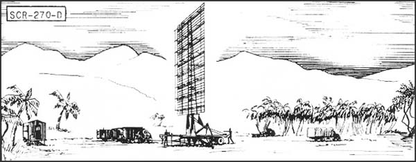
The 11.87 acre property was used in the location, construction, maintenance, and operation of roads, utility lines, and coast defense facilities in connection with La Jolla AWS Station. It was equipped with and SCR-270 radar

On 31 December 1949, the 11.87 acre property was declared as excess by the Deparment of the Army. Approximately 11.60 acres were transferred to the Department of the Navy on 28 September 1949, with another 0.17 acre transferred on 13 January 1956. Since then the Navy Public Works Center has operated the 11.77 acre site as the Mt. Soledad Signal Station. The remaining 0.10-acre license was terminated on 28 October 1952 and is now owned and operated by Midwest Television Incorporated
 
Coast Artillery data below also refernece the presence of an Army Air Forces aid to navigation activity known as VHF Site 3R and located on the site. Some Formerly Used Defense Sites documentation also indentify an aid to navigation site identified as VHF Site 3M colocated on the site. No other documentatio is currently available.
 
Location coordinates: 32°50'21.00"N 117°15'6.07"W
 
Source: Los Angeles District, US Army Corps of Engineers Prepared 1999
 
 
Radar at La Jolla Radar Sites B-12 and B-5
 
SCR-270-D Mobile Long Wave Aircraft Warning Set
 
 
Description: Six-vehicle mobile, long wave early warning aircraft detector. Azimuth and range supplied. Set is equipped with "A" scope.
Uses: To establish a screen of warning which provides information of approaching aircraft as early as possible but with a sacrifice of accuracy in range, azimuth and elevation. IFF equipment RC-150 is used.
Performance and Siting: Maximum range on a single bomber flying at indicated heights, when set is on a flat sea level site:
 
 Altitude, feet  1000   5000  20,000  25,000
 Range, miles  20  50  100  110
Set should be sited at a height between 100' and 1000' above an unobstructed reflecting surface.
Transportability: Complete set is carried in 6 vehicles, the largest of which measures 30'4" x 9'10" x 8'. Total weight of shipment is 101,790 lbs; total volume 11,485 cu. ft.
Installation: Operates from trucks in which mounted. Can be placed in operation about 6 hours after arrival at site.
Personnel: Seven men comprise operating crew. For 24 hour operation about 50 men are required to run radar, communication radio, and camp.
Power: 15.3 KW, supplied by PE-74, 25 KVA gasoline-driven generator, having fixed consumption of 4 gal. per hour, non-leaded gasoline.
 
 
Images of La Jolla Aircraft Warning Station


Mount Soledad Fire Control Station No. 2
 
A 250 ft x 200 ft parcel of land located immediately adjacent to and ajoining the northwest end of the La Jolla Aircraft Warning Service Warning Station. The site consited of a single two-tier fortified structure that provided fire control data for:
 
 
Click to view a larger image


Search our Site!
Google
Search the Web Search California Military History Online
 
Questions and comments concerning this site should be directed to the Webmaster
 
Updated 3 May 2016