Historic California Posts, Camps, Stations and Airfields
Oasis Gap Filler Annex, SM-164C
 
 
Typical AN/FPS-14 Gap Filler Radar
 
"During the late 1950s another area of progress was the development and deployment of AN/FPS-14 and AN/FPS-18 gap-filler radars. Having a range of around sixty-five miles, these radars were placed in areas where it was thought enemy aircraft could fly low to avoid detection by the longer-range radars of the permanent and mobile radar networks. Gap-filler radar deployment peaked in December 1960 at 131 sites throughout the continental United States. Because the introduction of gap-filler radars alleviated the need for civilians to scan the skies for enemy bombers, the ADC disestablished the Ground Observer Corps on January 31, 1959."
 
Searching The Skies
USAF Air Combat Command
June, 1997
 
Typical floorplan of a Gap Filler Annex


US Army Corps of Engineers Los Angeles District History (1993)
 
In November of 1956, the United States Department of Defense requested that 18.11 acres of land in the vicinity of Oasis, California be transferred from the Department of the Interior to the Department of the Air Force for use as an unmanned radar station to cover an area blocked by the terrain from the radar at Tonapah Air Force Station in Nevada. On 3 June 1957, the transfer was made official by notation on public land records.

The Air Force never made any improvements to the property. The land remained under the jurisdiction of the Department of the Air Force until May of 1960.
 
On 1 April 1960, the Air Force determined that no further requirement existed for the land and a declaration of excess was formally submitted to the Chief of Engineers Department of the Army. The land was thereafter relinquished to the Bureau of Land Management on 24 May 1960 and subsequently retransferred to the Department of the Interior by removal of the notation on public land records on 5 July 1960.
 
 
US Army Corps of Engineers Los Angeles District History (1992)
 
Location: Oasis Gap Filler Annex, Site SM-164C, is located 34 miles Northeast of Big Pine, California in Section 21, Township 6 South, Range 37 East, Mount Diablo Base and Meridian.

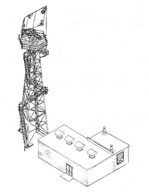
Site History: In November of 1956, the United States Department of Defense acquired 18.11 acres for use as part of the National Defense System in conjunction with Oasis Gap Filler Annex RE-D-6775. The intent of such an acquisition was for the construction of Gap Filler Radar Station on close to half an acre in the Southwest quarter of the southwest quarter of Section 21, Township 6 South, Range 37 East. The remaining land was to be used as an access road cutting across Sections 17, 20 and 21. Since it was suspected that such an access road might traverse school property, it was noted that necessary permits be obtained from the state before proceeding with construction. All 18.11 acres were public land to be reserved from the Bureau of Land Management by notation on the public land records indicating a military right of way and installation.

On 3 June 1957, Oasis Gap Filler was declared as excess and it was requested that action be taken to terminate Air Force use. Documentation indicates that no improvements have been made to the property, and the area has not been contaminated. Further, application number 0150684, Los Angeles, should be canceled and appropriate action be taken to remove the restrictions noted on the land office records. On 5 July 1960, The Department of the Interior Bureau of Land Management obliged by removing notation indicating military right-of-way and installation from said records.


Search our Site!
Google
Search the Web Search California Military History Online
 
Questions and comments concerning this site should be directed to the Webmaster
 
Updated 8 February 2016