Historic California Posts, Camps, Stations and Airfields
Orange County Army Air Field
(Santa Ana Radar Site L-39)
 
 
In 1923, aviation pioneer Eddie Martin built a private landing strip and founded a flying school on land owned by The Irvine Company. In 1939, the Airport became a publicly owned facility through a land swap between The Irvine Company and the County of Orange. Located five miles south of downtown Santa Ana, when it was taken over by the Army Air Forces as a training base. It also served as base for Navy blimps. In the postwar years it became John Wayne International Airport
Source: World War II Sites in the United States: A Tour Guide and Directory by Richard E. Osbourne
 
 
Orange County Army Air Field
by Justin M. Ruhge, Goleta Valley Historical Society
 
In 1942, the 4th Air Force, which was responsible for protecting the U.S. homeland, took over the Orange County Airport for use as a dispersal field. In early March 1942, the Field was turned over to the War Department by the County on a lease of $4,141 per year for 140 acres contiguous to the Airport for a new hangar and barracks and concrete revetments for aircraft protection. The County had already leased the 138-acre airport to the government.
 
For a while the field served as the headquarters for the 4t Fighter unit of the Western Defense Command. Its 332nd Fighter Squadron of the 329th Fighter Group flew offshore patrols using sixteen P-38 pursuit planes. On June 15, 1943 the Orange County Municipal Airport was redesignated the Orange County Army Air Field. The 332nd Fighter Squadron was disbanded at Santa Ana on March 31, 1944. The parent organization, the 329th Fighter Group, was headquartered at Grand Central Air Terminal, Glendale California from 1942 through March 31, 1944. On April 18, 1946 the Field was placed on the war surplus list. In May, the County again operated the Airport.
 
Eventually this field became the Orange County John Wayne International Airport.
 
References: The SAAAB Story by Edrick J. Miller, 1981.


US Army Corps of Engineers Los Angeles District History (30 September 1999)
ursuant to the General Directive No. RE-1180 approved 1 July 1942, the United States acquired by lease dated 3 August 1942 a portion of certain property commonly known as the Orange
County Airport, comprising 133.75 acres from Orange County. For the improvement and expansion of said airport, two other leases were executed with the Irvine Company in 1942 covering a 209.14 acre parcel and a 45.34 acre parcel. Additionally, 0.43 acres of easements were also acquired for the improvement of the airport from private parties. Total acquired property was 388.66 acres.

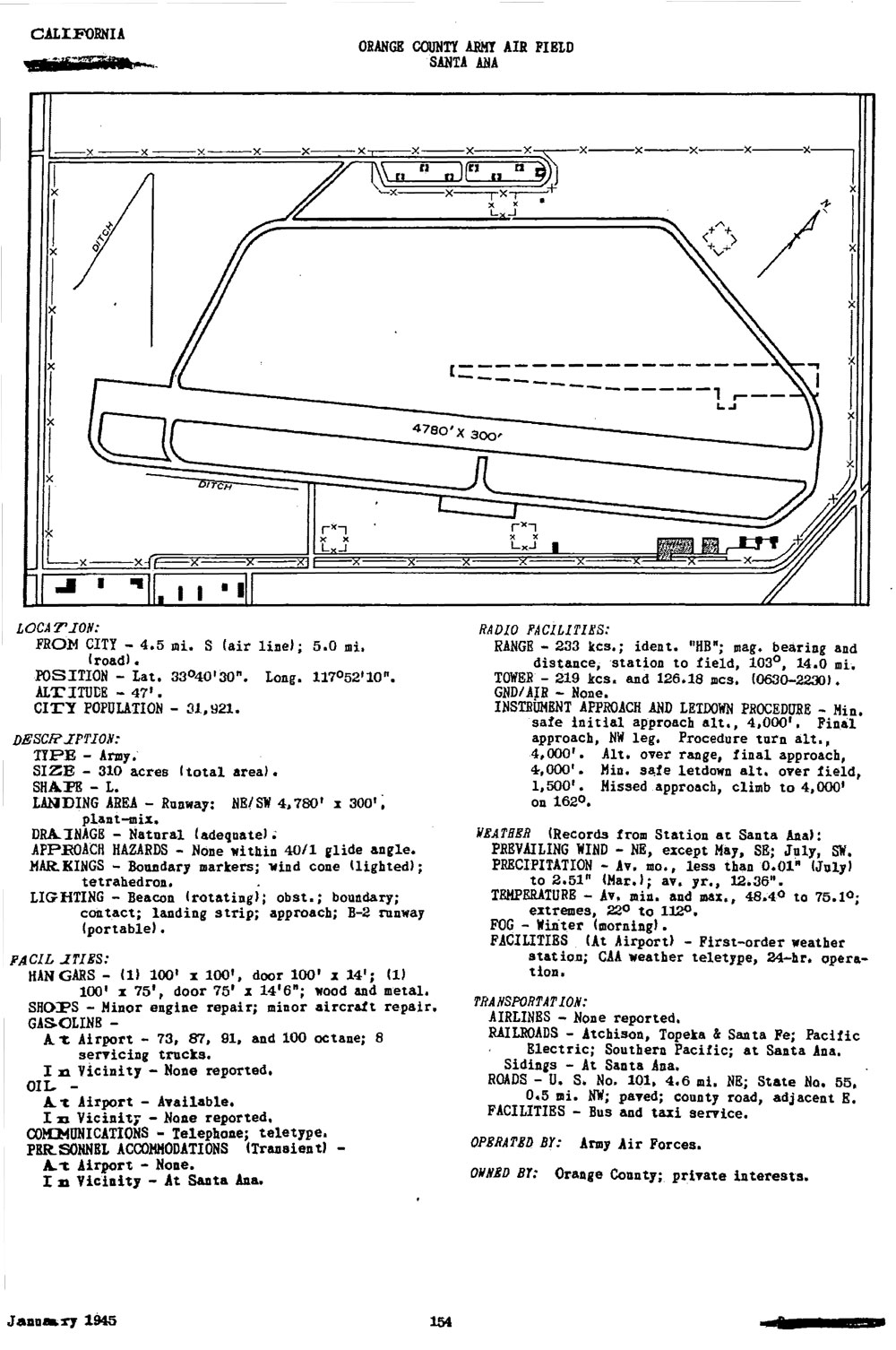
At that time, the developed airport was called Orange County Army Airfield. Improvements to the property included approximately 12 temporary type buildings, parking aprons, revetments, asphalt surfaced shoulders, aircraft protective concrete revetments, bomb storage revetments, lighting and electrical systems, water, sewage and storm drain facilities, runways, taxiways; fencing, and underground gasoline fueling system. The airfield was used by the Western Flying Training Command and by Headquarters, West Coast Air Corps Training Center stationed at Santa Ana Army Air Base.

The lease for 45.34 acres of Irvine Company land was terminated on 26 September 1946. On 16 January 1947, 39.64 acres of the 209.14 acres leased from the Irvine Company were released. These actions reduced the original 388.66 acres by 84.98 acres. The remaining 303.68 acres (including easements) along with the improvements, comprised Orange County Army Airfield and on 18 April 1946 this property and improvements were declared excess to the needs of the military and transferred to the War Assets Administration. In 1948, remaining leases were terminated and improvements transferred by the War Assets Administration to the County of Orange contingent upon the condition that the leased premises, together with the chattels and improvements, be used for public airport purposes.

Presently the property has been developed into a commercial and general aviation airport known as John Wayne Airport.
 
 
US Army Corps of Engineers Los Angeles District History (11 August 1992)
 
In 1940, construction of a new county airport was begun with a 2,500 ft. paved runway and taxi strip on what is now the approximate southerly half of John Wayne Airport. In 1942 the government leased the airport (133.75 acres) and contiguous property to the west, east, and south (254.91 acres) for its use and constructed improvements including buildings, utilities, fencing, bomb storage revetments, and underground fueling system. Following use of the airport by the U.S. Army Air Forces during World War II, 84.98 leased acres were released and 303.68 acres were declared excess and transferred to the War Assets Administration. In 1948, the War Assets Administration terminated the leases and transferred the improvements to the County of Orange with the condition that the leased property and improvements be used for public airport purposes. Since that time, extensive expansion of the airport and private, commercial and street and highway development of the perimeter land has taken place. The magnitude of this development and growth of the airport and surrounding vicinity supports the assumption that prior government improvements (underground fueling system and ordnance storage, most specifically) have long since been removed. There is no visible evidence on site which would indicate that there are any residual eligible hazards present at this time, nor is there any indication in the site history subsequent to 1948 that any eligible hazards exist.
 
US Army Air Forces Directory of Airfields (January 1945)


Santa Ana Radar Site L-39
 
Established in March 1942 this Army Air Force air defense radar site was located on Orange County Army Air Field, now John Wayne International Airport (33°40'56.62"N 117°51'48.18"W). The site was initially operated by 654th Signal Aircraft Warning Company. It was later replaced by the 653rd Signal Aircraft Warning Company. Both were assigned to the Los Angeles Control Group. The radar used was the SCR-588 Long Wave Aircraft Detector and Ground Control Intercept Radar.
 
SCR-588 Long Wave Aircraft Detector and Ground Control Intercept Radar

 
Description: Fixed medium-range, long wave aircraft detector and GCI. Provides azimuth, range, and altitude data. Type HR and PPI scopes.
 
Uses: To give continuous plan position and accurate relative height of enemy plane and friendly fighter plane for GCI. Set can also be used for early warning and to give increased coverage at low angles of search. IFF equipment RC-188 is used. When operating as GCI, VHF equipment SCR-624 is required.
 
Performance and Siting: Maximum range on a medium bomber, with set on flat sea level site:
 Altitude, feet

 1,000

5,000

10,000

 25,000
 Range*, miles

 20

 50

 95

 105
*Range of PPI limits GCI operation to about 45 miles.
 
When operating as GCI, set must be sited so that a flat unobstructed surface extends at least 1/4th mile in the height-finding sector. Good GCI sites are extremely rare. For early warning, sets should be sited between 100 and 1,000 feet above an unobstructed surface.
Transportability: Set is packaged for shipment in 55 units, weighing a total of 54,000 lbs. Largest unit measures 15.3' x 3.8' x 1.8'. Total shipping space is 3500 cu. ft.
 
Installation: Requires a weatherproof building approximately 20' x 40' for housing radar components and a building approximately 20' x 20' for power units and switchboard. A 25' tower on concrete footing is required for support of antenna. Buildings and tower can be built by Engineers in about 3 weeks. Radar can be installed by 5 men in 2 weeks.
 
Personnel: 8 men are operating crew. For 24-hour operation about 54 men are required to run radar, communication radio, and camp.
 
Power: 4 KW at 230 volts and 1 KW at 115 volts, from three PE-198 electric diesel units, supplied with set. (Two units operate simultaneously). Fuel consumption is 21/2 gals. of Diesel fuel oil per hour.
 
 
Search our Site!
Google
Search the Web Search California Military History Online
 
Questions and comments concerning this site should be directed to the Webmaster
 
Updated 8 February 2016