Historic California Posts, Camps, Stations and Airfields
Otay Mesa Radar Site B-8/J-8
(Camp Minnewawa)
 
 
US Army Corps of Engineers Los Angeles District History (5 January 1995)
 
The Army acquired a total of 3570.94 acres of land for the Otay Mesa Installation. A 6-acre campsite (former Civilian Conservation Corps Camp Minnewawa) was acquired on July 1, 1942 from G.R. Daley. Approximately 3560.09 acres were acquired on March 31, 1945 from the Department of the Interior. A 20-foot right-of-way consisting of 4.85 acres was leased from the Otay Agricultural Corporation in 1945.

The site was used as a radar installation and coastal defense site. Concrete bunkers were built to house the radar units and diesel generators that powered them. The campsite was used to house the personnel that operated the site.

The 6-acre campsite was returned to G.R. Daley on January 10, 1947. The old campsite is currently a private campsite called Thousand Trails Pio Pico and is owned by Thousand Trails. The 3560.09 acres were returned to the Department of the Interior on February 8, 1949 and are in use as a communication complex by the federal government under the authority of the Bureau of Land Management. The 4.85-acre right-of-way lease with the Otay Agricultural Corporation was terminated on January 4, 1949. Information regarding current use of the 4.85-acres is not available. No information was found under the name of the Otay Agricultural Corporation.
 
Former Civilian Conservation Corps Camp Minnewawa, cantonment area for the Otay Mesa Radar Site (B-8/J-8)


US Army Corps of Engineers Los Angeles District History (March 1999)
 
The US Army acquired a total of 3570.94 acres of land for the Otay Mesa Installation. A 6-acre campsite was acquired on July 1 1942 from G.R. Daley. Approximately 3560.09 acres were transfered from the Department of the Interior by Use Permit on March 31, 1945. A 20-foot right-of-way, for an access road, consisting of 4.85 acres was leased from the Otay Agricultural Corporation in 1945.

The site was used as a radar installation, known as Radar Station AWS B-8/J-8, and coastal-defense site. The campsite was known as Camp Minnewawa, and was used to house the personnel that operated the site. Concrete bunkers were built to house the radar units and the diesel generators that powered them. 3. The 6-acre campsite was returned to G·.-R. Daley on January 10, 1947. The old campsite is currently a private campsite called Thousand Trails, Pio Pico and is owned by Thousand Trails. The 3560.09 acres were returned to the Department of the Interior on February 8, 1949, and are Public Domain Lands. The 4.85-acre right-of-way lease with Otay Agricultural Corporation was terminated on January 4, 1949. The site currently contains communications equipment near the summit of Otay Mountain. Additionally, the site is heavily patrolled by the US Border Patrol.
 
Site B-8 was operated by the 68th Signal Aircraft Warning Company and was equipped with the SCR-270B Mobile Long Wave Aircraft Warning Set. Technical data for the similar "D" variant below. Site J-8 was operated by the 654th Signal Aircraft Warning Company and was equipped with the SCR-588 Long Wave Aircraft Detector and Ground Control Intercept Radar. Both units were subordinate to the San Diego Control Group. Exact date of unit assignment is not currently known.
 

Site Map


Radar Sets at Otay Mesa
 
SCR-270-D Mobile Long Wave Aircraft Warning Set (Site B-8)
 
 
Description: Six-vehicle mobile, long wave early warning aircraft detector. Azimuth and range supplied. Set is equipped with "A" scope.
 
Uses: To establish a screen of warning which provides information of approaching aircraft as early as possible but with a sacrifice of accuracy in range, azimuth and elevation. IFF equipment RC-150 is used.
 
Performance and Siting: Maximum range on a single bomber flying at indicated heights, when set is on a flat sea level site:
 
 Altitude, feet  1,000  5,000  20,000  25,000
 Range, miles  20  50  100  110
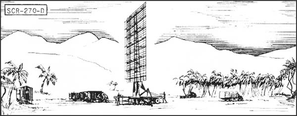
Set should be sited at a height between 100' and 1000' above an unobstructed reflecting surface.
 
Transportability: Complete set is carried in 6 vehicles, the largest of which measures 30'4" x 9'10" x 8'. Total weight of shipment is 101,790 lbs; total volume 11,485 cu. ft.
 
Installation: Operates from trucks in which mounted. Can be placed in operation about 6 hours after arrival at site.
 
Personnel: Seven men comprise operating crew. For 24 hour operation about 50 men are required to run radar, communication radio, and camp.
 
Power: 15.3 KW, supplied by PE-74, 25 KVA gasoline-driven generator, having fixed consumption of 4 gal. per hour, non-leaded gasoline.
 
Location coordinates: 32°35'37.59"N 116°50'45.86"W
 
 
SCR-588 Long Wave Aircraft Detector and Ground Control Intercept Radar (Site J-8)

 
Description: Fixed medium-range, long wave aircraft detector and GCI. Provides azimuth, range, and altitude data. Type HR and PPI scopes.
 
Uses: To give continuous plan position and accurate relative height of enemy plane and friendly fighter plane for GCI. Set can also be used for early warning and to give increased coverage at low angles of search. IFF equipment RC-188 is used. When operating as GCI, VHF equipment SCR-624 is required.
 
Performance and Siting: Maximum range on a medium bomber, with set on flat sea level site:
 Altitude, feet

 1,000

5,000

10,000

 25,000
 Range*, miles

 20

 50

 95

 105
*Range of PPI limits GCI operation to about 45 miles.
 
When operating as GCI, set must be sited so that a flat unobstructed surface extends at least 1/4th mile in the height-finding sector. Good GCI sites are extremely rare. For early warning, sets should be sited between 100 and 1,000 feet above an unobstructed surface.
Transportability: Set is packaged for shipment in 55 units, weighing a total of 54,000 lbs. Largest unit measures 15.3' x 3.8' x 1.8'. Total shipping space is 3500 cu. ft.
 
Installation: Requires a weatherproof building approximately 20' x 40' for housing radar components and a building approximately 20' x 20' for power units and switchboard. A 25' tower on concrete footing is required for support of antenna. Buildings and tower can be built by Engineers in about 3 weeks. Radar can be installed by 5 men in 2 weeks.
 
Personnel: 8 men are operating crew. For 24-hour operation about 54 men are required to run radar, communication radio, and camp.
 
Power: 4 KW at 230 volts and 1 KW at 115 volts, from three PE-198 electric diesel units, supplied with set. (Two units operate simultaneously). Fuel consumption is 21/2 gals. of Diesel fuel oil per hour.
 
Location coordinates: 32°35'35.38"N 116°50'40.76"W


Search our Site!
Google
Search the Web Search California Military History Online
 
Questions and comments concerning this site should be directed to the Webmaster
 
Updated 8 February 2016