The Santa Barbara Presidio
was the last in the line of Spanish defenses that began in North
America on the Atlantic Ocean in Florida with the founding of
the first presidio on the then western front of the new world
at Saint Augustine in 1565, 217 years earlier. The unrelenting
conquest of the new world by the Spanish Empire ended with this
last redoubt at the final western front on the shores of the Pacific
Ocean. As with the San Francisco Presidio, the driving force behind
a presidio at Santa Barbara was Father Junipero Serra. He passed
through the area on foot several times and saw that there were
many Native American villages between Point Conception and the
southern end of the Santa Barbara Channel at present day Ventura.
This region was a big gap in the control of Spain between the
Presidio at Monterey and that at San Diego. The nearest mission
was at San Luis Obispo. Only the Spanish horse mail express ever
passed through this region on a regular basis.
The Spanish were great bureaucrats
and needed a paper trail for everything. Serra started it with
his requests. The Council of War and Royal Treasury approved his
requirements. The King gave Felipe de Neve, who was appointed
Governor of the Californias in October 1774, the task of preparing
a new reglamento. This requirement was transferred from the royal
council to the Viceroy, who gave it to the Commanding General
Croix of the Provincias Internas, who gave it to the new governor,
Neve, in August 1777. Neve based his plans on the earlier Regulations
of 1772, which have been described in an earlier part of this
work. Neve submitted his new Regulations for Governing the Province
of the Californias to Croix in June of 1779. These were approved
by Croix and sent to the new viceroy, Marin de Mayorga, with the
recommendation that the King put them into effect on an interim
basis pending approval. With approval of the King on October 24,
1781, the Neve Regulations became law. These regulations applied
to the presidios of Alta and Baja California, to the Department
of San Blas and to a certain extent to the missions. Included
were provisions for the establishments of three missions - San
Buenaventura, La Purisima and Santa Barbara and a presidio, which
must be located at the center of the Santa Barbara Channel.
In the meantime the Viceroy
directed Neve on April 19, 1776 to move the capital of the Californias
from Loreto to Monterey and to take charge of the affairs of Alta
California. Neve arrived at Monterey from San Diego on February
3, 1777 after passing through the Santa Barbara Channel where
he obtained first hand knowledge of the Native Americans and the
terrain. In a letter of that date to the viceroy, Neve makes the
following statement: "The site which I observed to be most
suitable for establishment of the fort (presidio) is in the vicinity
of Mescaltitlan, the three towns opposite Yslado and in a dominant
and open place. But having to consider the problem of defense
and the availability of cultivatable fields, a special reconnaissance
is necessary in order to find out more about it. Soldiers must
come equipped with weapons and mounted, with two cannon of 4 for
the presidio if Your Excellency approves it's founding.
In this case, the shipment
of clothing and provisions must be sent by ship, and for this
there will have to be a determination as to which of the bays
or harbors of the Channel will be more secure to anchor the ships
and unload their cargo. Without doubt it should be near the site
marked for the fort, concerning which Frigate Lieutenant Diego
Choquet, who anchored in the year 1776 next to the three villages
of the Channel, will be able to advise you."
Neve's first impressions
led him to favor the location around the present day town of Goleta
at the location of the Santa Barbara Airport. This was in Neve's
time a slough with two islands in the middle and several Native
American villages. The name Mescaltitlan was applied to this site
by the Portola Expedition in 1769 because it resembled a similar
slough and island in the Mexican province of Nayarit on the west
coast of Mexico above San Blas, the homeland of many of the early
settlers brought to Alta California by the Spanish. Neve did recommend
further detailed exploration of the area before a final decision.
He referred to a visit by the ship El Principe that was carrying
Father Serra south to San Diego in 1776, which tied up in front
of the Mescaltitlan location. Neve also recommended supplying
any further settlements with supplies brought by ship. A survey
to find the best harbor in the area was recommended.
A letter dated September
3, 1778 from Croix, Commanding General of the Provincias Internas,
to Governor Neve gave official approval for "erection of
a presidio with a garrison composed of a lieutenant, a sergeant,
two corporals and twenty-six soldiers in the center of the Channel
of Santa Barbara, and, under the protection of the presidio, a
mission with the same name and another named San Buenaventura."
The pueblos of San Jose and Los Angeles were also approved.
Once the decision had been
made, plans were formulated to carry them out. As in the expeditions
to found the three earlier presidios, a two-pronged effort was
undertaken to bring supplies by sea and to round up soldiers,
settlers and cattle in Mexico and to move them by land to the
area to be settled. Months of letter writing containing instructions
and plans followed between Governor Neve, the viceroy and General
Croix who was at Arizpe in Sonora, Mexico.
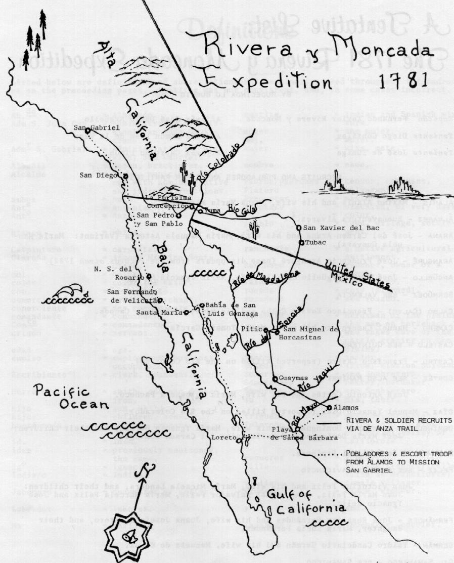
Once again it fell to Captain
Fernando de Rivera y Moncada, Lieutenant Governor of Baja California
at Loreto, to cross over to the mainland from Loreto and recruit
the needed personnel and cattle from primarily Sinaloa and Sonora.
The settlers were to start the pueblos at Los Angeles and San
Jose and the soldiers were to sign up for ten years to man the
new presidio on the Channel. Twenty-four families, thirty-four
soldiers, and over 900 animals were to be moved nearly 1,000 miles
to the north.
The group of 261 settlers
and six soldiers gathered at San Miguel de Horcasitas in Sonora,
north of Hermosillo. The settlers then went south to Alamos for
equipment, clothing, provisions, livestock and pay. Once provisioned,
the settlers split into two groups. The families and cattle heading
for Los Angeles and San Jose went north by way of Tucson and the
Colorado River following the De Anza trail to San Gabriel Mission,
leaving in April 1781 and arriving on July 14,1781. The second
group crossed the Gulf of California by boat from Playa de Santa
Barbara to Loreto and then again by boat north along the coast
to Bahia de San Luis Gonzaga where they landed and then followed
the Portola route up the Baja peninsula to San Diego and San Gabriel.
This group arrived August 18, 1781. The list of names of all involved
was published in Antepasados, Los Californianos, Vol. IV, 1980,
pgs. 59-64.
The first group was accompanied
by Captain Rivera as far as the Colorado River where he remained
behind on the east band to rest the cattle. On July 17, 1781 the
Yuma Native Americans attacked the Spanish settlements on the
east side of the river and massacred the inhabitants. At least
forty-six were killed including Captain Rivera and other members
of the group going north. Thus ended a long and distinguished
career by a devoted Spanish soldier who was one of the founders
of the State of California.
The combined groups camped
at San Gabriel during the winter of 1781 to 1782. During that
time the Pueblo of Los Angeles was founded on September 4,1781
with twelve settlers and their families - forty-six persons in
all. The push further north to San Jose was delayed pending better
weather.
Meanwhile Lieutenant Jose
Francisco Ortega, who was transferred from his post as Commandante
of the San Diego Presidio to the same position at Santa Barbara
by Governor Neve, was training the recruits for the Santa Barbara
Presidio.
We will remember that Ortega
was with the Portola Expedition and is credited by history to
be the first European to see the San Francisco Bay. This same
Ortega was directed by Governor Neve to explore the Channel for
the best location for the new presidio. The spot that he picked
turned out to be the present location of the San Buenaventura
Mission in Ventura. Governor Neve was interested in finding a
location in the middle of the channel and took an active part
in exploring the area.
With improved weather the
expedition of 200 people with horses and mules departed San Gabriel
on March 26, 1782. This group included 60 soldiers with Lieutenant
Ortega at the lead. After three days of marching, the expedition
arrived at the present location of the San Buenaventura Mission.
Father Serra finally achieved his goal of establishing a mission
at the south end of the Santa Barbara Channel. A cross was raised,
a temporary tule chapel was built and on Easter Sunday, March
31, Serra sang the first Mass. With the help of the soldiers and
the local Native Americans a palisade was constructed and water
was diverted from the Ventura River through a newly constructed
aqueduct.
Governor Neve left Sergeant
Pablo Cota in charge of fourteen soldiers to protect the mission
and continue building the new structures. On April 15, 1782 Governor
Neve and the remaining soldiers set out for the trip to Santa
Barbara, a distance of 27 miles. This trek was made in one day.
Upon reaching the present location of the Santa Barbara Presidio,
Neve again conducted a survey of the whole area from Mescaltitlan
to the present location. Paramount to a choice was a place where
a ship could be anchored near enough to unload heavy equipment
and close to the site of the Presidio. Two brass four-pounder
cannon were to be sent to the Presidio by ship when a location
was selected. As in the earlier expeditions, the Royal Navy out
of San Blas, Mexico supported this one. Two ships were sent in
1782 to deliver food and equipment to the presidios.
The Princesa was a frigate
built at San Blas. She was 189 tons, 92 feet long, 24 feet beam,
15 feet Draft. She was armed with six four-pounder and four three-pounder
iron cannon.
The packet Favorita was
purchased by the Spanish Navy from Peru. She was 193 tons, 72
feet long, 25 feet in beam, and 15 feet in draft. No cannon were
reported for this ship.
Before starting this expedition,
the Princesa had just returned from a long and hazardous voyage
to the Philippines. Both ships were well known on the northwest
coast for many years.
Don Esteban Josef Martinez commanded this expedition in support
of the founding of the Santa Barbara Presidio. These ships were
sent to the north in 1782 to supply San Francisco and Monterey.
They were then to sail south to the location of the central coast
and to look for the land portion of the expedition. Pantoja Y.
Arriaga was the second pilot on the Princesa. One of the pilot's
duties was to keep the ship's log. In a voyage such as this he
also conducted surveys and prepared maps of the new area. While
the area had been explored by land, it was not mapped in detail
by sea. The log of the Princesa on this voyage was first translated
by H. R. Wagner and published in 1935 and again by Geraldine Sahyun
and edited and published by Richard Whitehead in The Voyage of
the Princesa in 1982. From this record is obtained a description
of the area of Mescaltitlan Island, as the Princesa and Favorita
were moving south.
"Before reaching
the last point, in the 2nd of the 3 before mentioned, are the
bay, lake, and islands of Mescaltitlan, and on passing at about
a league's distance from it a large opening is to be seen, which
appears to have a large bay in the center and around its circumference
many trees. It is the largest forest to be seen on all this coast
of ravines. Several rancherias were seen in it, having a numerous
Indian population with many canoes."

The two ships continued south while the Princesa fired her cannon to attract the attention of the land party. Hearing the ship in the distance, the land party prepared a signal fire to attract the attention of the sea party. They finally met at the present Santa Barbara roadstead. A flag had been raised at the point to the south of there. This was later named Point Martinez in honor of the commander of the Princesa. At this time Governor Neve had already decided on the location for the presidio at Santa Barbara on April 21, 1782. However, to back up his decision, Neve ordered the ship commander to send the pilot Pantoja Arriaga to Mescaltitlan to conduct a complete survey. The record of this survey is as follows:

The report of this survey is taken from the Whitehead book and
modified as it appeared in Gunpowder and Canvas by the author.
These comments and the resultant maps are the only record of the
original Mescaltitlan area that comes down to us today. The survey
was made on August 12, 1782 when most streams were dry and the
effect of the sandbar was most evident. Had the survey been made
in January the sandbar may not have existed, there would have
been water in the streams and the result may have been different.
However as a result of this pivotal survey, the decision was made
by Neve to go ahead with the selection of the present location
of Santa Barbara. His decision was stated in a letter to Galvez
from General Croix dated August 26, 1782.
Neve picked Santa Barbara
instead of Mescaltitlan because: "besides the advantages
of the land, the grass and lumber, stones, and water, the last
three of which were missing in the second place, the chosen site
at Santa Barbara, is less than a quarter of a league from the
only sheltered place along the coast that is suitable for anchoring
ships." Other considerations were the overlook to the east
that the site in Santa Barbara provided by the high ground above
present Garden Street and the low marshy estero in that direction
which was a barrier to any attack from that direction. At Mescaltitlan
the presidio would have to be located on More Mesa or almost two
miles back from the harbor above present day Hollister Road or
on Mescaltitlan Island itself, which was heavily populated by
Native American villages. At the Santa Barbara location, the only
village was off a mile from the proposed location of the presidio
and considered a safe distance. At the present day Goleta location,
there were five large Chumash villages. The Santa Barbara site
was also out of cannon shot of most shipping. The other consideration,
water, seemed to be better provided by the present Mission Creek
than was the case in the Goleta area in August of that year. So
for all these reasons the fame and importance that has come to
the Santa Barbara location has passed by the Goleta location.
Had dredging been available to the Spanish in 1782, the Goleta
lake and sandbar could have been deepened as is done every year
today at the Santa Barbara harbor and a very impressive city built
at the Goleta location, instead of just the present day airport.
But then that is history!
As in the founding of the
earlier presidios, the first structure was a palisade enclosure.
Governor Neve returned to Monterey leaving Lieutenant Ortega with
forty-one soldiers to begin the work. A location for the permanent
presidio had been determined so the temporary structure was offset
and would not interfere with the future construction site. Work
began on an enclosure of oak palings to enclose an area of 165
feet square with two small bastions. The permanent structure was
to be 220 feet on a side also with two small bastions, but made
of adobe blocks. On June 2, 1782, Neve made an inspection of the
presidio status just five and a half weeks after the founding.
He reported to Commanding General Croix that: "the plastering,
flat roofs, storehouse, guardhouse and barracks remained to be
finished and that the natives were still happy about the Spanish
settlement." In other words, much still had to be done. "The
governor was complimentary of Lieutenent Ortega on most counts,
but said he had to reprimand him for being too familiar with the
troops. He also lacked firmness and determination, and his accounts
as paymaster were in such bad shape, in spite of his intelligence
in such matter, that Neve recommended he be quickly replaced.
He said that if Ortega continued as paymaster the inevitable result
would be bankruptcy. Neve considered him a good officer under
the direction of another commander."
On August 1, 1782 the long
awaited supply ships arrived with the much-needed uniforms, food,
and the two bronze four-pounder cannon. Neve gave Ortega explicit
instructions as to how the supplies were to be handled and inventoried.
In September 1782 Neve was appointed Inspector General of the Internal Provinces and Pedro Fages succeeded him as Governor of the Californias residing at Monterey.


Enlarged section of the Pantoja Map showing the details of the Mescaltitlan area, now the Santa Barbara Airport. Note the numerous Native American rancherias in 1782. From Gunpowder and Canvas by the Author.
By the end of 1782, the
mandatory strength report listed Ortega as commanding officer,
Josef Arguello as his alferez, or ensign, in addition to Sergeants
Pablo Cota and Josef Olivares, Corporals Alejandro de Soto and
Josef de Ortega and fifty soldiers. Fifteen were in the escolta
at San Buenaventura, seven at San Luis Obispo on a temporary assignment
and two were in Los Angeles. This left thirty-two men at Santa
Barbara available for duty, not a large force for the area under
Spanish control.
Water was brought to the
palisade by means of an aqueduct from the Mission Creek. A letter
from Neve to Galvez dated October 20, 1783 states: "The numerous
Indians who inhabit the said Channel remain quiet and tranquil,
and according to the latest news I have received from the said
Ortega, they have gladly and voluntarily labored on the buildings
of the presidio and the aqueduct constructed from the source of
the Pedregozo, distant a quarter of a league, to bring water to
the presidio's very walls facing its principal entrance"
- from Geiger, Life and Times of Serra II, 289-290. The aqueduct
may have ended in a fountain outside the walls and a washbasin,
and perhaps also a reservoir.
Governor Neve's displeasure
with Lieutenant Ortega was displayed when he appointed Don Felipe
Antonio de Goycoechea as Comandante of the Santa Barbara Presidio
on January 14, 1783. His family was centered at Alamos in Sonora,
Mexico. The reader will remember this as the starting place of
the expedition to settle Santa Barbara. Goycoechea joined the
army at thirty-five and moved up in rank quickly. He had good
family connections and extensive experience on the Mexican frontier.
He bore the title "Don" for that reason. His family
was of noble Basque lineage. He commanded the Presidio at Loreto
for a year before being appointed to the comandante of the Santa
Barbara Presidio. He held this post from January 25,1784 to 1802
after which he was Governor of Baja California for eight years.
Ortega was transferred to
Loreto. He applied for retirement in 1786 after 30 years of service
but was denied. He continued in the service until he was retired
as a brevet captain in 1795 but attached to the Santa Barbara
fifty company. He died at his Spanish Land Grant ranch at Refugio
Canyon twenty miles west of Santa Barbara on February 3, 1798.
With the appointment of
Goycoechea, work began in 1785 on the permanent structures of
the Presidio. Construction proceeded along the lines of the Reglamentos
of 1772 using a formula that we have already seen for the earlier
presidios in California. Walls were to be made of adobe with a
chapel, three large warehouses, guardhouse, comandante quarters,
family quarters, soldier's quarters and two bastions. Gardens
separated the quarters from the outer defense walls. One gate
was located facing the ocean as with the other presidios. A smaller
gate was located on the east side. At Santa Barbara the main gate
was on the south side of the quadrangle and the chapel in the
wall on the north side. The comandante's quarters were at the
right of the chapel and the married officers on the left. The
outer walls were about 400 feet on each side. The inner parade
ground was about 300 feet square. There was a casa mata outside
the walls near the east bastion where the supply of about 350
pounds of gunpowder was stored. Two corrals were located on each
side of the entrance behind the walls so that the horses could
be watched by the guards at the entrance. Footings were excavated
and filled with stone as foundations for the adobe blocks in the
walls.
Construction began in 1785
with the construction of thousands of adobe bricks 11"x 22"x
4''. Soldiers, Spanish ship's crews, and the Chumash Native Americans
all took part in the construction and all were paid for the work.
The Chumash were paid one and a half reales per day and five quarts
of corn. Wood beams were first taken from local trees but found
to rot quickly so pine and redwood beams were ordered from Monterey
and sent down by ship. Roof tiles were manufactured at the Presidio.
The south row of buildings nearest the ocean which contained the
warehouses and the main gate was constructed first, followed by
the west side soldiers quarters, the north side with the comandante's
quarters and the chapel, and finally, the east line of buildings.
The outer defense wall was constructed last. Most of the buildings
were completed by 1788, but the outer defense wall took over three
years more to complete. The defense walls were four feet thick
and nine feet high. The final steps were plastering the walls
and whitewash. This went on for several years more.
The Santa Barbara Presidio
construction avoided the mistakes of the earlier presidios, in
that it did not first build a flat roof covered with plaster,
followed by thatch, followed by tile, but built with tile in the
first construction thus saving a huge amount of labor and maintenance.
Most of the buildings had overhanging front porches supported
by poles. A well was located in the inner quadrangle. The work
proceeded briskly because it had the full support and attention
of the Governor and the Viceroy. As buildings were constructed,
the old palisade structure was vacated and torn down. There was
some suggestion that there was a dry moat around the Presidio
but none has been discovered to this time.
A document in the Bancroft Library dated September 16,1788 from Goycoechea to Governor Fages describes in detail the status of construction on the Presidio as of that date. Geraldine Sahyun translated this document in the 1960s. Incorporated in the document is a plan of the Presidio with a number for each building, the length, breadth and height of each room, and the materials of construction for the building or room. The map indicated that it is a statement to Governor Fages, prepared by Goycoechea showing the present state of construction of the Presidio. Bancroft's scribes on tracing cloth, using both sides of the tracing cloth, traced the copy in the Bancroft Library from the original. As a result, the ink has bled through the cloth and the document is difficult to read. The Newberry Library has a similar map of the Presidio with the same date but signed by Governor Fages. The Fages map is also a tracing of the original Goycoechea map. The map itself has been lost to history, but the Fages tracing map was found in the Archivo General de la Nacion in Mexico City. It is much clearer than the Bancroft map and has some measurements added that were omitted in the original Goycoechea map. The Newberry document is "Plan del Real Presidio del Canal de Santa Barbara," by Pedro Fages, September 16, 1788, MS in Map Collection of the Richman Papers, Newberry Library, Chicago, Illinois. This map appears in its original Spanish form in Citadel On The Channel by Richard S. Whitehead, pg. 116. A clean copy of the Bancroft map also appears on page 191 with an English translation on page 192. Details of the materials and construction of the presidio can also be found in Citadel On The Channel, Chapters 8 and 9.
On August 21, 1790 Goycoechea
submitted a report to Governor Fages listing the names of the
officers, soldiers, and other residents of the Presidio; their
race, age and place of birth; the name, race and age of their
wives; and the names and ages of their children. There are sixty-one
officers and soldiers and six other men listed. With their wives
and children, there were 230 people living in the Presidio.
In October 1794 Goycoechea
ordered that construction expenses should stop and only work on
the chapel and maintenance of the completed buildings would be
allowed.
The first non-Spanish Europeans
visited the newly completed Presidio in November 10-18, 1793.
The English Captain George Vancouver visited Santa Barbara with
his three-ship flotilla, the Discovery, the Chatham,
and the Daedalus. The English were welcomed by Comandante
Goycoechea, who made every effort to supply, feed and entertain
his guests for
the 18-day visit. Vancouver describes his impressions of this
Presidio as he did the others in his journals published in Europe.
He reports seeing two brass nine-pounder cannon at the entrance
to the Presidio. He also observes that the location of the Presidio
and harbor could be made more secure by the placement of a fort
on the hill about a mile away, which was about 150 feet above
it and had a clear field of fire over it. Eventually, a fort was
built at that location.


Vancouver's comments on his impressions of the Santa Barbara Presidio from his journals as presented in Gunpowder and Canvas by the Author, pgs. 2 - 51. We have been told that there were two brass Four-Pounders at the Presidio. Vancouver recommends a fort on the hill on the southwest side of the roadstead.
Vancouver also commented: "The buildings appeared to be regular and well constructed, the walls clean and white, and the roofs of the houses were covered with a bright red tile. The presidio was the nearest to the sea shore, and just showed itself above a grove of small trees, producing with the rest of the buildings a very picturesque effect." Vancouver also stated that the presidio excels all the others in neatness, cleanliness and other smaller though essential comforts and that it is placed on an elevated part of the plain and is raised some feet from the ground by a basement story, which adds much to its pleasantness.
At the time of Vancouver's visit, the Presidio had just been completed
and had not yet seen the wear of the other three presidios visited
by him. Also much better construction techniques and materials
were used in this Presidio since it was the latest and last to
be constructed. The comment about nine-pounder cannon conflicts
with the earlier information that they were four-pounders requested
by Governor Neve. At a later date, eight-pounder cannon were placed
at the fort on the hill. The Presidio was built on a slight hill
with the northeast end being higher than the southeast by about
eight feet. The northeast end did not have a basement. John Sykes,
chief artist with this expedition, rendered the first drawing
of the Presidio and the Mission. It shows the Mission and the
Presidio with the chapel peaking up over the walls, a tower or
torreon on the right side and no bastions. Apparently, the torreon
was added after Goycoechea submitted his 1788 plan since it was
not shown then. The newly completed mission was also visible.
Following Vancouver's visit,
as we have seen in the earlier parts of this work, the Spanish
government became concerned about the threat from foreign powers.
On October 17, 1794 Viceroy Marques de Branciforte began a program
of studies and improved fortifications.
In 1796, work was underway
to enlarge the Presidio chapel from 54 to 99 feet long. The enlarged
chapel was consecrated on December 12th.
In a letter to Governor Borica dated April 10, 1797, Goycoechea
describes the Presidio cannon as "6-caliber", meaning
pounder, or firing a six-pound ball. Still more confusion.
The coast of California was rocked with one of the strongest earthquakes
in California history in December of 1812. Estimated at over 8.5
on the Richter scale, the results were devastating to the Spanish
adobe structures. Almost every building in Alta California was
damaged or destroyed. The Presidio was heavily damaged and never
recovered from this event.
Captain Jose Antonio de la Guerra y Noriega became Comandante
of the Presidio in 1815.
In 1818 the coast of California
was attacked by the Argentine revolutionary, Hipolite Bouchard.
The widespread and steadily growing feeling of hostility throughout
the Maerias for the colonial systems of Europe, which first became
strongly manifest in the American Revolution, was brought with
startling suddenness to the attention of Californios on October
6th. There arrived at Santa Barbara the American brig Clarion,
sailing from the Hawaiian Islands, with the terrifying news that
two ships, the Argentina and the Santa Rosa, were outfitting at
Honolulu for an attack on the California coast. These insurgent
ships flew the flag of the rebel government of Buenos Aires and
they were commanded by Captain Hipolite Bouchard and Lieutenant
Peter Corney respectively. Nearly 400 armed men were in their
crews.
Captain Jose de la Guerra,
immediately upon reception of this news, sent couriers to warn
Governor Sola at Monterey and the missionaries of the more exposed
missions along the coast of the impending attack. When De La Guerra
received the required permission from the Governor, he prepared
to evacuate the women and children of Santa Barbara, along with
those articles of value that could be moved, across the Santa
Ynez Mountains to the safety of the Santa Ynez Mission. Though
Captain Bouchard carried a commission from the Buenos Aires government,
the frightened officials of California branded him and the members
of his crew as pirates. After sacking Monterey on November 22nd,
Bouchard sailed south and appeared off Gaviota on December 2nd.
He landed at Refugio and attacked the Ortega Rancho. The ranch
was sacked and cattle killed but the residents and their valuables
had disappeared into the mountains. The Spanish did manage to
capture three of the insurgents. All of the troops and Native
Americans that could be mustered were gathered to stop Bouchard
without effect. Bouchard debarked and sailed south to Santa Barbara
followed by this large Spanish land contingent at which he fired
several cannon balls without effect. There he sent a man ashore
under a flag of truce to ask for a parley to which Comandante
de la Guerra agreed. In the course of this parley, Bouchard proposed
that, for an exchange of prisoners, he would leave the coast.
De la Guerra agreed and transferred the three prisoners taken
at Refugio and received in exchange a drunken settler whom Bouchard's
men had picked up in Monterey. After the exchange was consummated,
Bouchard continued his voyage south and after a stop at San Juan
Capistrano, was seen no more.
In 1820 the Spanish government
had an unknown artist visit the four Alta California presidios
and prepare a not-to-scale drawing of each showing what features
were there at the time of the drawing. The drawings, held at the
Bancroft Library, have already been discussed for the earlier
presidios in this work. For Santa Barbara, the rear of the chapel
is shown protruding beyond the defensive wall, the chapel bell
tower is indicated on the left front as "Torrecito",
a tower is shown in the east wall near the comandante's quarters
as "torreon de dos cuerpos" or watchtower, the main
gate is shown and two small side gates in the east and west walls.
There are no bastions shown. A defensive wall encloses the buildings.
The main gates are on the inside wall. No water well is shown
although Vancouver refers to one during his 1793 visit. A number
of buildings owned by the Presidio soldiers are shown outside
the Presidio, as is the case at the other presidios at this time.
1822 marked a change in
management of the presidios. The Mexican revolution ended the
Spanish rule of King Ferdinand VII with the government of Mexican
Emperor Agustine Iturbide the First. Everyone in California was
required to pledge allegiance to the Emperor. On April 13, Presidio
Comandante Jose de la Guerra lowered the flag of Spain over Santa
Barbara. As we have seen in earlier sections of this work, this
event marked the beginning of the end of the presidios.
Many of the soldiers of the presidios were assigned to the missions to control the Native Americans and to capture any that attempted to run away. The Santa Barbara Presidio provided its soldiers to six missions: San Fernando, San Buenaventura, Santa Barbara, Santa Ynez and Purisima Concepcion. As we have seen elsewhere in this work, there were many revolts of the Native Americans against the harsh treatment of the soldiers and the Spanish government in general. A revolt broke out at Santa Ynez as a result of an order given by Corporal Manuel Cota of the guard there. As a punishment for a shortcoming that was real or fanciful, one of the soldiers of the guard at Mission Santa Ynez trussed up a Purisima neophyte who was visiting friends at Santa Ynez and flogged him brutally. This mistreatment proved to be the spark necessary for the ignition of the powder keg. A general uprising followed immediately at the three Santa Barbara missions and an attempt was made at San Buenaventura Mission. At Santa Ynez, the Native Americans attacked the soldiers, who defended themselves behind the thick walls of the mission building. No lives were lost in this attack, but in the fighting inflammable material within the building was set on fire and a part of the structure was burned. This happened on a Sunday February 22, 1824. The next day the news of the conflict having been carried to the Presidio in Santa Barbara, a military force under the command of Sergeant Carrillo arrived on the scene and prepared to give battle to the insurrectionists. The Native Americans gave up the fight and fled to the Purisima Mission. Here the Native Americans took possession of the buildings. Corporal Tapia with the four soldiers stationed there barricaded themselves in their quarters along with the members of their families and the two missionaries and fought off the Native Americans until their supply of powder gave out. During this fight four whites and seven Native Americans were killed. The whites surrendered but were released by the Native Americans and sent to Santa Ynez. Then the Native Americans prepared to defend themselves against the attack that they knew would be launched against them.
In Santa Barbara the Native Americans tried to disarm the soldiers
at the mission, but when they resisted, a fight ensued and the
soldiers were badly beaten. Outraged by this depredation, Captain
de la Guerra led a large force to the mission. In the battle that
followed, two of the Native Americans were killed and three others
wounded. Four of the soldiers were wounded. With no results the
troops withdrew to the Presidio. The Native Americans then broke
into the storerooms and took what provisions they could carry
and retreated up Mission Canyon with their families. De la Guerra
and his soldiers again attacked the mission but found the Native
Americans gone. The soldiers sacked the Native American village
and captured some women and took them off to the Presidio. Later
four old Native Americans from Dos Pueblos encountered a band
of soldiers who killed them.

The main body of the Native
Americans escaped to Tulare Lake in the Central Valley. In April
1824, Captain de la Guerra dispatched Lieutenant Narcisco Fabrigat
and his Mazatlan soldiers, originally rushed to Alta California
in 1818 during the Bouchard attack on coastal ports, to bring
the truant Native Americans back from the Valley. Eighty picked
soldiers engaged the Native Americans at San Emigdio where two
encounters took place in which four Native Americans were killed
and a number of men on each side were wounded. The fugitives took
advantage of a dust storm and escaped. In June Governor Arguello
offered the Native Americans at Tulare a full pardon and the Mission
Padre Ripoll, whom they trusted, induced them to return to the
Santa Barbara Mission.
In the meantime, Governor
Arguello sent a large force from Monterey to Purisima to reduce
the rebels there. After a short fight, the rebels asked their
Padre Rodriguez to intercede for them and to arrange surrender.
This was done. There was supposed to be a pardon as with the Santa
Barbara rebels. However as an aftermath of this conflict, seven
Native Americans were shot as murderers, four were sentenced to
ten years of hard labor at the Presidio, and then to permanent
banishment, and eight others were condemned to the Presidio for
eight years. The padres were outraged by the severity of this
punishment but the governor would not relent and thought stricter
punishment was deserved.
This whole event showed
a complete lack of consideration by the Spanish for the plight
of the Native Americans and was the last nail in this peoples'
coffin leading to their ultimate extinction. Alta California was
a province of Mexico after the revolution. Governor Echeandia
called an assembly of electors in San Diego in February 1827.
This assembly chose Comandante Jose de la Guerra of Santa Barbara
to represent them for a two-year term in the congress organized
in Mexico City. De la Guerra was Spanish-born and not allowed
to serve under the new laws of Mexico which prohibited Spanish
under 60 from living in Mexico unless married to a Mexican-born
wife. He elected to go anyway. After a difficult journey to Mexico
and a harrowing escape, Captain de la Guerra returned to Santa
Barbara where he found Mexican-born Don Romualdo Pacheco in the
position of Comandante. De la Guerra then retired at Santa Barbara
to manage his large land holdings and to finish work on his grand
adobe casa which still stands today on De la Guerra street. Captain
de la Guerra was allowed to stay in California as a result of
his fame and position in state affairs and a pardon from Governor
Echeandia. In later years he again became the comandante.
The French explorer, A. Duhaut-Cilly visited Santa Barbara on August 29, 1827. His ship Le Heros was of 362 tons with a crew of 32 men and 72 guns. He also published his comments about the Presidio in his journals, as did Vancouver. His brief comments follow:

Duhaut-Cilly traveled the
California Coast for about a year, stopping at Santa Barbara on
several occasions. He left California in August 1827 and returned
to France via Hawaii and Canton, China.
The above quote tells us
that Captain de la Guerra was in the process of building his adobe
casa in 1827, that he purchased beams for it from Monterey, and
that he was appointed to represent the province in Mexico City.
He mentions a bastion on the Southeast corner of the Presidio,
which was not shown in the 1820 drawing. This is the first reference
to the existence of this structure. There had been doubt that
it ever existed. But he states that it is of poor quality. He
refers to a balcony at the comandante's quarters which must be
the tower mentioned in the 1820 drawing. However, he places the
comandante's quarters at the northwest corner of the Presidio
while it was on the right side of the chapel or the northeast
corner. The tower was also located on the 1820 drawing at this
corner.
Due to the poor conditions
that existed at the four presidios after California became a province
of Mexico, the soldiers complained for years of lack of pay and
provisions. At Monterey, a political agitator named Joaquin Solis
from Chile had recently come to Monterey with a contingent of
ragtag soldiers and convicts sent by the Mexican government. He
was a fiery orator and talked the soldiers at the Monterey Presidio
into a revolt against the Mexican government. On November 12,
1829 he seized control of the Monterey Presidio. He then left
a contingent of his own followers in charge and took 100 men to
San Francisco where he convinced the Presidio there to surrender
and join the cause. Again, leaving a few loyal supporters in charge,
Solis proceeded south to Santa Barbara to take control of the
Presidio there. A group of Americans at Monterey formed an opposition
party to Solis and sent a courier to warn Governor Echeandia at
San Diego of the approaching army of about 200 men. Echeandia
arrived there after two weeks and took command of the Santa Barbara
Presidio. He sent a courier to Solis promising amnesty to any
rebel who would desert. Solis crossed Refugio Pass and made camp
in Refugio Canyon, where he sent a return message to Echeandia
demanding surrender and stating he would in turn grant amnesty.
The Governor ordered all residents of the town to the Presidio,
except for thirty old women whom he sent to the Scottish ship
Funchal anchored in the harbor. On December 13, 1829 the Presidio
army of 90 headed by Comandante Pacheco encountered the Solis
army near Cieniguitas, present day Modoc and Hollister streets.
Pacheco beat a hasty retreat to the Presidio. Solis marched to
within a mile of the Presidio in the vicinity of Mission and De
La Vina streets where he set up cannon and opened fire on the
Presidio. The governor returned the cannon fire. For three days
cannon balls were lobbed back and forth without hitting anything.
Solis then ran out of gunpowder and provisions. The Solis army
returned to Monterey where it was captured by the American army
loyal to the government. Joaquin Solis was eventually deported
to his native Chile. As historian H. H. Bancroft phrased it, "the
battle of Santa Barbara" was the first in which Californian
was pitted against Californian."
Alfred Robinson was an early visitor and settler in California. After years of business and a long life in California, he published Life in California in which appear the second earliest known drawings of Santa Barbara entitled "Presidio (or Town) of Santa Barbara, Nueva California. From a Hill Near the Castillo, Founded April 21, 1782", dated 1829. He draws the Presidio without walls. Just to the left of the Mexican flag appears to be the tower (torreon) of the Presidio mentioned in the 1820 drawing. The de la Guerra adobe is to the left with its second story, Altito; and Burton's Mound is in the foreground. The mission is shown with two towers.
The Santa Barbara Presidio fell into disuse after becoming part
of Mexico for the same reasons presented earlier in this work
as did the three other presidios. The transition from the presidio
to the pueblo resulted in the construction of private homes around
the original structure and the sell-off of parts of the Presidio
for that purpose so that with time the Presidio disappeared into
the pueblo. The chapel was abandoned for the new parish church
in 1854. The walls slowly dissolved and parts of the decaying
structures of the Presidio were salvaged for building materials
for new adobes.
In 1841 the French government sent their Mexican attaché, Duflot de Mofras, to California to learn as much as possible about the Mexican settlements there since it had been 14 years since Duhaut-Cilly's visit. Unlike the former visitor, de Mofras did not have a formally outfitted expedition. He moved from place to place on ships of convenience. He first arrived from San Blas on the ship Ninfa in May 1841. He stayed in areas for months to observe the culture and study the economic conditions. He described his findings in a two-volume book that was published in France in 1844 entitled Duflot De Mofras' Travels on the Pacific Coast by Marguerite Eyer Wilbur, Ed, and trans. 1937. The De Mofras comments reveal that the Presidio is deteriorating but still staffed by a garrison of 15 soldiers and 5 officers. There are one four-pounder (iron) and two bronze eight-pounders cannon. The hide and tallow trade is well established since hide sheds have been erected near the shore. The "Spanish battery" is now razed. This reference verifies that the battery did exist. A drawing in De Mofra's books shows the location and chevron shape of the "battery".

In 1844, the "Kings Orphan" visited Santa Barbara and
prepared two pencil sketches of the pueblo. The tower in the 1820
drawing is shown, however no walls or bastions are visible. The
intact bell tower in front of the chapel is clearly visible. A
flagpole with flag is shown in one view. The de la Guerra adobe
is shown on the left view along with the two-story Alpheus B.Thompson
adobe. The Mission is shown in the background with two towers.
In one view, a building is shown on Burton's Mound in the foreground
along with a beachside "hide house" to the right.
U.S. Naval Lieutenant James Alden with the U.S. Coast Survey drew the next view of the Presidio in 1855. He visited the Presidio and drew the chapel showing the ruined bell tower, an intact but deserted chapel and the melted defense walls and some of the collapsed buildings on either side of the chapel. A triangular buttress to prevent collapse supported the back of the chapel.
The chapel bells are shown
mounted on a rack in front of the ruins of the bell tower. The
chapel was abandoned after 1855 when the new parochial Our Lady
of Sorrows Church replaced it as the place of worship in Santa
Barbara. The original drawing of the chapel is located at the
Santa Barbara Mission Archives Library.
Edward Vischer visited all the missions and presidios in 1865
and prepared drawings of the missions and some of the presidio
remaining buildings. One of his pictures of Santa Barbara shows
the one remaining building that housed the soldiers' family, called
El Cuartel. To the left of this drawing and just underneath the
eave is an image of a three-masted sailing ship in the roadstead.
Other ships appear on the right side in the background.
Henry Chapman Ford made
a drawing of the Casa de la Guerra on the backside in 1886 presenting
the complete view of the "Altito" or second story supposedly
built by Captain de la Guerra to house his gold. This structure
has since been removed but it is seen in early
photographs of the Casa.
In 1895 Walter A. Hawley
of Santa Barbara became interested in the history of the Presidio
and the Mission. He retained a civil engineer and had the remains
of the Presidio surveyed and a map prepared drawn with pencil
on heavy brown paper. The map is located in the files of the Santa
Barbara Mission Archives Library. As a result of his historical
research on Santa Barbara, Hawley published a book in 1910 entitled
Early Days of Santa Barbara. The book was republished in 1920
by Mrs. Hawley and again in 1987 by John C. Woodward with additional
illustrations. The history of the Presidio, Mission and ranchos
as well as many other historical events were presented. At the
time of this publication in 1910, El Cuartel, the comandante's
quarters and the Canedo Adobe were the only parts of the Presidio
still standing. The Canedo Adobe is at the far left of the chapel
location. It was once used to house Presidio soldiers and their
families. The adobe was later granted to Jose Maria Canedo, a
Presidio soldier and extensively remodeled in the 1940's by Elmer
Whitaker.
The earthquake of 1825 severely
damaged the comandante's quarters. The building could not be repaired
and was torn down.
By 1911 the chapel no longer existed. The Chinese settled in and around the old Presidio compound. On the old chapel site the Chinese constructed a two-story Buddhist Temple. This structure lasted until 1967 when it was torn down to begin the Presidio reconstruction.


Underneath the site were found the brick-lined vaults of Spanish
and Mexican Presidio residents buried in the chapel.
The Santa Barbara Presidio
is the only one of the five Spanish presidios that has been partially
restored. Primarily the north side, which includes the chapel,
has been restored. Part of the comandancia and the torreon in
the east line of buildings has also been restored.
The Santa Barbara Trust
for Historic Preservation, a non-profit organization, was formed
in 1963 with restoration of the Presidio as its primary objective.
The trust then acquired, restored and donated El Cuartel to the
State. Later El Presidio de Santa Barbara State Historic Park
was formed. El Cuartel is the oldest building owned by the State
of California. Several other properties in the Presidio area have
been acquired for the project, including the Canedo Adobe and
the site of the Presidio Chapel. The Trust operates the State
Park under an agreement with the State Department of Parks and
Recreation.
Archeological investigations
within the Presidio's quadrangle have been conducted since the
mid-1960s. A large portion of the fort's stone foundations has
been located. Extensive and ongoing research in original Presidio
documentation has provided much information about the Presidio's
history. As a result of these investigations, the Trust has been
able to reconstruct the padre's quarters, the chapel, comandancia,
and torreon with the assistance of the California Conservation
Corps and volunteers working under professional supervision.
Excavations have also located
the aqueduct from the reservoir at Mission Creek near the Mission
that entered the Presidio at the rear of the comandancia. To date,
the casa mata has not been found. Some think it is located on
the Rochin property at 820 Santa Barbara Street. No cannon from
the presidio period have been recovered. Cannon were movable and
either found a new home on some ship, were buried or sold for
scrap.
While State, County and
City revenues have been provided for land acquisition in the Presidio
quadrangle, the planning and financing of reconstruction have
been largely the Trust's responsibility.
Many of the local place
names and family surnames of Santa Barbara are due to the first
settlers of the Presidio and to the Comandantes and Governors.
Most of the pioneers were from the western provinces of Mexico,
only a few were from Spain. In the following list the Comandantes
of the Presidio are reviewed.
The officers of the Presidio
were civil as well as military and consisted of the comandante,
who had sometimes the rank of lieutenant but generally that of
captain; and the habilitado, who had charge of all branches of
the revenue and was generally postmaster. The duties of habilitado
were frequently discharged by the comandante.
The first comandante was
Captain Jose Francisco Ortega, born in Guanajuato, Mexico. He
was engaged in mining in early life but moved to Baja California
where he entered the military service. He served as Comandante
at Santa Barbara and Monterey and continued to perform military
service until shortly before his death. He supervised the construction
of the temporary palisade presidio and constructed the first water
supply for the presidio and farm plots.
In 1784 Ortega was succeeded
in command by Captain Felipe de Goycoechea, who was the Comandante
at Santa Barbara until 1802. During his term of office the permanent
Presidio was constructed and most of the mission buildings were
finished.


A rendering of the Presidio based on the 1788 Comandante Goycoechea Plan, drawn by Russell A Ruiz and on display in the Museum of the Comandanica in the northeast corner of the restored Presidio. Photograph by the Author, 2001.


After leaving this assignment, he was made Governor of Baja California.
Goycoechea was succeeded by Lieutenant Raimundo Carrillo, who
for five years was Comandante at the Presidio and discharged the
duties of his office with firmness yet clemency.
This period was memorable
because of the earthquake of 1806, which damaged not only some
of the buildings of the Mission but also the Presidio Chapel.
The walls of the latter were badly cracked and a severe gale almost
completely destroyed the edifice. Carrillo was born in 1749 at
Loreto, the capital of Baja California; and came to Alta California
about twenty years later, becoming a soldier. He served as a corporal
at Monterey and later as a sergeant at Santa Barbara. He was made
lieutenant and Comandante at Monterey and two years later was
Comandante at Santa Barbara.
Captain Jose Dario Arguello,
who for nine years was Comandante at Santa Barbara, succeeded
Carrillo in command. Captain Arguello was born in Queretaro, Mexico
in 1755 and when twenty years old enlisted in the army. One of
the most important acts of his administration was the opening
of common schools but unfortunately they received little public
support. During this time the disastrous earthquake of 1812 occurred
in December causing great damage to many of the buildings at the
Mission and elsewhere in California. Extensive damage to the Presidio
resulted from this event. Some considered reconstructing the Presidio
on another site. For a short time Arguello was acting governor
of Alta California and served for several years as Governor of
Baja California. Arguello was one of the most influential men
in California where he resided for thirty-four years.
Arguello was succeeded in 1815 by Captain Jose Antonio de la Guerra y Noriega whose command extended over 24 years. He was born in Spain in 1779 of a distinguished family and while still very young moved to Mexico to live with his uncle. He entered the army as a cadet and occupied several military positions until 1806 when he was promoted to Lieutenant of the Santa Barbara Presidio. In 1810 he was chosen Habilitado General of both Californias and sent to Mexico but was arrested by Mexicans during the revolution and returned to Santa Barbara. In 1815 he was appointed Comandante which office he occupied with a few interruptions until 1842. He was promoted to Captain soon after his appointment to Comandante. During his long life Captain de la Guerra exercised a strong influence in the political affairs of Alta California. He died in 1858 and was buried at the Mission.
Gumesindo Flores, a Mexican brevet lieutenant colonel who was
Comandante at Monterey from 1839 to 1842, succeeded De La Guerra.
Flores was actively engaged in territorial affairs during his
short term as Comandante at Santa Barbara and is regarded as the
last Comandante, although Raimundo Carrillo was acting commander
during his absence for part of the year of 1846. In December of
1846 Captain Fremont crossed the Santa Ynez Mountains with his
American battalion and occupied Santa Barbara during the conquest
of California.
References
The following documents were used for references and excerpted
to prepare the foregoing history of the Santa Barbara Presidio:
The Narrative of James O. Pattie by James O. Pattie; The History
of California by H.H. Bancroft; Early Days of Santa Barbara by
Walter A. Hawley; Exploration of the Coast of Southern California
in 1782 by Henry R. Wagner, Quarterly Publication of the Historical
Society of Southern California, pgs. 135-138; California Pictorials
by Jeanne Van Nostrand and Edith M. Coulter; Fabricas by Elisabeth
L. Egenhoff; A Brief Story of Santa Barbara by Edward Selden Spaulding;
Old Spanish Santa Barbara by Walker A. Tompkins; Royal Presidio
of Santa Barbara Archaeology of the Chapel Site by Brian Fagan;
The 1781 Rivera y Moncada Expedition by Rudecinda Lo Buglio, Anteposados
Volume IV 1980-1981, pgs.59-64; The Voyage of the Frigate Princesa
to Southern California in 1782 by Richard S. Whitehead; Gunpowder
and Canvas by Justin M. Ruhge; Felipe de Goycoechea: Santa Barbara
Presidio Comandante by Jarrell C. Jackman; Citadel on the Channel
by Richard S. Whitehead; California Missions Studies Association
WWW.Ca-Missions.Org
|
|
|
|
| 1781 | Jose Francisco de Ortega | September 8, 1781 to January 25, 1784 |
| 1784 | Felipe Goycoechea | January 25, 1784 to August 31, 1802, Appointed on January 17, 1783 in Loreto |
| 1802 | Jose Raimundo Carrillo | 1802 to 1807 |
| 1807 | Jose Arguello | January 1, 1807 to October 13, 1815 |
| 1815 | Jose de la Guerra y Noriega | October 13, 1815 to January 1, 1828, Suspended part of 1828 to 1830 |
| 1819 | Gabriel Moraga | December, 1819 to April, 1821 (Acting only) |
| 1828 | Romuldo Pacheco | December, 1828 to November, 1829 and April to August 1830 (Acting only) |
| 1828 | Romuldo Pacheco | April to August 1830 (Acting only) |
| 1830 | Jose de la Guerra y Noriega | November 1, 1830 to November 2, 1832 |
| 1833 | Juan M. Ibarra | July 1833 to April 1836 |
| 1837 | Jose Castro | December 25, 1837 to March 1838 |
| 1838 | Jose Ma. Villa | April 1838 (Acting only) |
| 1839 | Jose de la Guerra y Noriega | January to December, 1839 |
| 1840 | Jose de la Guerra y Noriega | June and July, 1840 to October, 1841 |
| 1841 | Gumesindo Flores | November, 1841 to March, 1844 |
| 1845 | Jose Carrillo | September 3, 1845 |
| 1846 | Gumesindo Flores | Again appointed January 26, 1846 |
| 1847 | Henry S. Burton | May 26, 1847 |
| 1847 | Francis J. Lippitt | July, 1847 to September 8, 1848 |
| 1848 | Captain Smith | September 8, 1848 |
Source: Santa Barbara Trust for Historic Preservation
Source: Santa
Barbara Trust for Historic Preservation