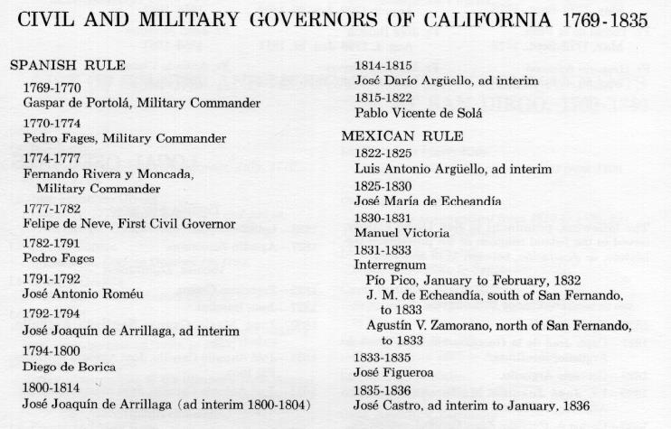
Historic California
Posts, Camps, Stations and Airfields
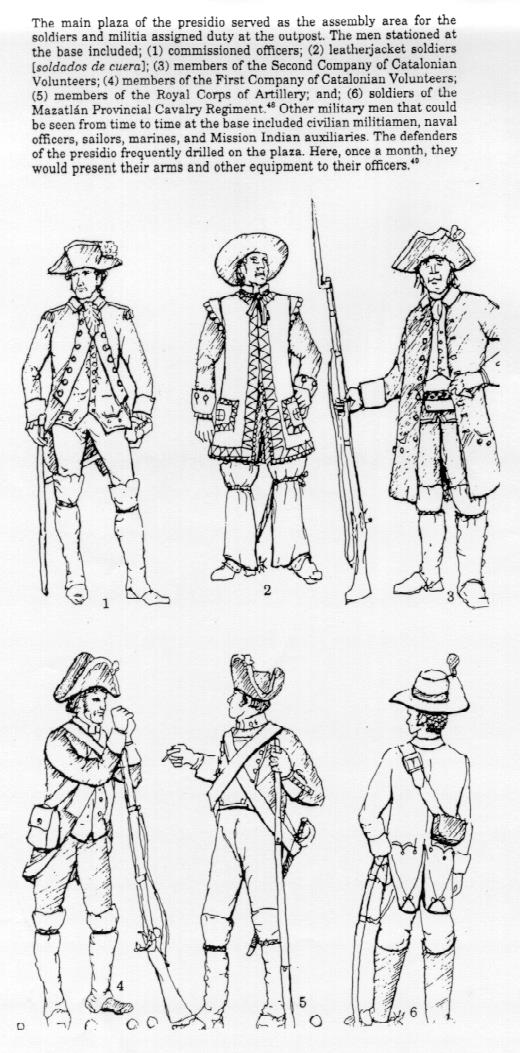
El Presidio Real
de San Diego, 1769
by Justin Ruhge
Sergeant Jose Francisco
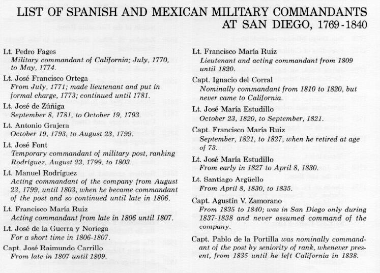
Ortega was in charge of the soldiers at San Diego. Captain Vila
of the San Carlos decided to return to San Blas. Only five sailors
had survived the scurvy but with them and two soldiers and two
muleteers he departed.
In June 1770, Captain Fernando
Javier de Rivera y Moncada, whom Portola had dispatched to Loreto
on February 10 to secure food, returned with 20 additional soldiers
and cattle and supplies.
The records of the mission
are lost for the following year. But by March 12, 1771 the Fathers
had succeeded in baptizing a few Native Americans who lived in
the woods at the bottom of Presidio Hill in the village called
Cosoy. On this date the San Antonio also returned with 10 fathers
for the new missions commissioned by the Viceroy. The military
governor, Pedro Fages, reported to the Viceroy that he felt the
situation at San Diego was good and he could proceed to develop
the new missions. The next missions to be founded were San Antonio
de Padua, San Carlos Borromeo de Carmel and San Gabriel near Los
Angeles.
The San Carlos and the San
Antonio returned in August 1772 with much needed food to end a
new famine, and the first flock of sheep to arrive into California.
In late 1772 Father Serra decided to sail on the returning San
Carlos to go to Mexico City to meet with the new Viceroy, Antonio
Maria Bucareli y Ursua, about his needs in California and to request
the replacement of the military commandant Pedro Fages with whom
he had bad relations.
Captain Rivera was appointed
military comandante and Sergeant Ortega was promoted to lieutenant
and placed in charge of the military at San Diego.
We learn about the settlement
at San Diego from Father Francisco Palou in his official report
to his superiors in 1772: "The mission is situated on a high
elevation about two gunshots from the beach, looking toward Point
Guijarros and the mouth of the port named San Diego, which is
in 32 degrees and 42 minutes north latitude. The beach, as also
the vicinity of the mission, is peopled by savages, since within
a district of 10 leagues there are more than 20 large rancherias,
and one other adjoining the mission. Within the stockade is the
church or chapel, constructed of poles and roofed with tules,
as also the habitation of the two missionaries, having the requisite
rooms partly of adobe and partly of wood and roofed with tules.
Likewise, within the stockade, is a similar structure that serves
as the barracks for the soldier guards and as a storehouse for
the supplies. For defensive purposes, within the stockade, are
two cannons of bronze. One looks toward the port, and the other
toward the Indian rancheria. On one side of the stockade, in the
wall, is an opening for the foundations of a church 30 yards (varas)
long. For this some stones and 4,000 adobes have already been
prepared. The foremen of the work are the Fathers, and the workmen
are the neophytes, who labor with pleasure. Of the cattle, which
came for these new missions from Lower California by order of
Inspector-General Jose de Galvez, this mission was allowed 18
head, large and small. In the beginning of last October it had
40 head. It then owned also 74 head of sheep, 55 goats, 19 pigs,
15 mares, 4 fillies, 1colt, 8 tamed horses, 1 jackass, 6 donkeys,
4 riding mules, and 18 pack mules with the necessary outfits.
The mission possesses 12
plowshares and other iron implements. There is also a sufficient
supply of tools for carpenter and for masons, and a forge for
the blacksmith, although there are no mechanics to teach these
crafts."
On January 1, 1774 San Diego
was raised to the status of a Royal Presidio. The location of
the stockade was in an indefensible place. A hill was above it
and no one with military sense would place a fortification where
it was located. Perhaps the start of the chapel had something
to do with the decision to stay where it was but better military
judgment would have moved the presidio up to the top of the hill
where it would be immune to attack from above.
Rivera assumed his new post
and Fages withdrew. Prior to this time, San Diego and Monterey
had been occupied by the missionaries and the military. Now the
age of settlement opened. Rivera went to Sinaloa to begin recruiting
married soldiers, who were to take their families with them to
the frontier. He gathered together a party of 55 persons and they
crossed over from San Blas to Loreto aboard a new ship, the Concepcion.
There he ordered Ortega to come south to Velicata and escort the
families to San Diego and to Monterey, while he went ahead to
assume his new command. These were the first real colonists of
California arriving 18 months before those who were taken north
to San Francisco over the desert route by de Anza. They trod the
now established Pacific trail that Serra and Portola had first
broken on their way to San Diego five years before. These first
colonists arrived at San Diego on September 26, 1774. Most of
the colonists moved on to Monterey.
In this year, the Viceroy
approved the move of the mission farther up Mission Canyon to
its present location and away from the Presidio. The move was
made in August. Some of the soldiers were stationed at the mission,
which was about six miles away but in view of Presidio Hill.
The trials and tribulations
of supplying the Alta California missions and settlers by sea
made the Spanish look closely at the possibility of an overland
route through Arizona to the settlements 600 miles to the north.
Father Serra requested support for this venture and the Viceroy
asked Engineer Miguel Costanso to estimate the distance and suggest
a possible route. Enter Don Juan Bautista de Anza, captain of
the Tubac presidio in the Apache territory and a descendant of
two generations of Spanish frontier soldiers. De Anza had heard
from the Pima Native Americans about the exploits of the Spanish
on the Pacific coast. He realized that there must be a direct
communication route between the tribes in the desert and mountains
of the southwest. On May 2, 1772, de Anza wrote a letter to the
new viceroy, Don Antonio Maria Bucareli y Ursua explaining to
him his plan for an expedition through the mountains. His letter
was referred to Costanso who confirmed it with his own experience
on the Portola expedition. Bucareli decided to support the expedition,
which would go first to San Gabriel Mission and then on to Monterey.
On January 8, 1774 a group of 34 persons including Fathers Graces
and Juan Diaz, a Native American named Sebastian Tarabal who had
been over most of the land to the north, and 35 pack loads of
provisions departed from Tubac. This trek was to lead to the eventual
founding of the third presidio in Alta California. After blazing
a historic first trail through the deserts and mountains of the
southwest, the de Anza expedition arrived at San Gabriel on March
22nd. The Mission was on famine rations until the ship from San
Blas arrived with Father Serra and supplies. De Anza went on to
Monterey and then returned to Tubac by a shorter route blazed
by Father Garces who had preceded him. He covered about 1,800
miles of new routes in five months. Stopping only briefly at Tubac,
de Anza continued on to Mexico City where he met with Bucareli
to present his report. Bucareli was very pleased with what he
saw and promoted de Anza to lieutenant colonel of cavalry and
gave bonuses to seventeen soldiers who had accompanied him.
Elated by these successes,
in 1775 Bucareli ordered Rivera and Serra at Monterey to go north
to the San Francisco area and thoroughly explore the Bay and then
locate sites for a mission, presidio and pueblo on the point of
land now called the Golden Gate. In the same year, de Anza was
ordered by the Viceroy to organize a land expedition from Sonora,
Mexico to the Golden Gate to found the settlement of San Francisco.
Only the second group of settlers to be sent north since 1769.
The expedition was organized
at Culiacan. Altogether, there were 240 persons, including thirty
soldiers, some with their wives, four other families of colonists,
and 115 children. In addition there were herders, interpreters,
muleteers, servants and twenty army recruits; 140 pack mules carrying
food and among other things, women's clothing and four casks of
brandy; 450 saddle horses and riding mules and 355 cattle. Father
Pedro Font was chosen to be the diarist and observer, and Fathers
Garces and Eixarch were to accompany him as far as Yuma and remain
there to work among the Native Americans whose cooperation was
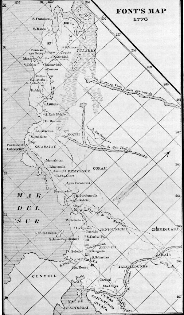
so necessary. Father Font produced a now famous map of this expedition
of 1776.
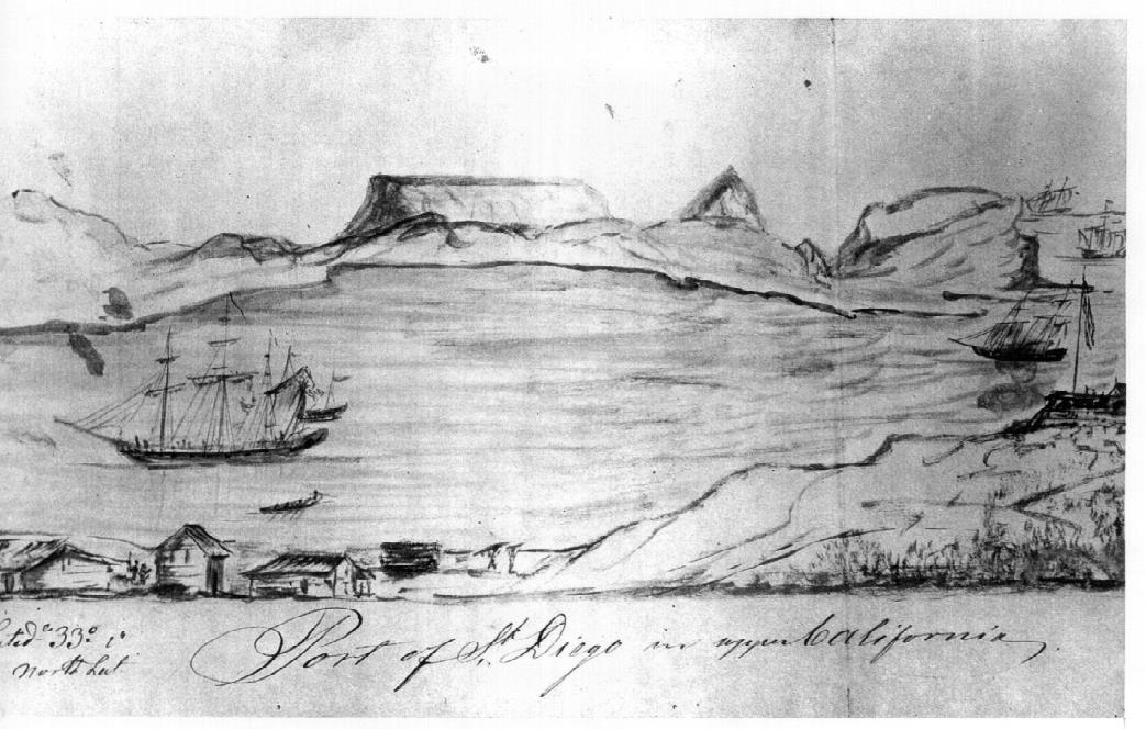
Father
Pedro Font's map of the Second Expedition of De Anza.
His map Shows the route From the Yuma Crossing of the Colorado
River, and the California Coast from South of San Diego Bay to
San Francisco Bay, with settlements and trails.
From The Explorers by Richard F. Pourade, Page 173. From
the Collection of The James S. Copley Library, LaJolla, California.
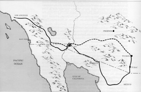
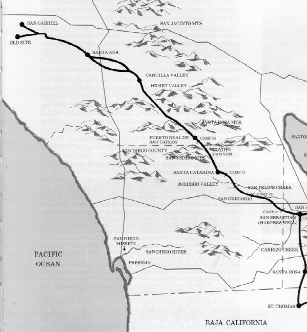
Upper,
map showing de Anza's Route From Tubac in 1774 and again in 1775
with a large group of settlers bound for San Francisco. Lower,
map showing de Anza's route through San Diego and Riverside Counties
in 1774 and with settlers in 1775. In each case, the destination
bypassed San Diego for the San Gabriel mission near Los Angeles.
From The Explorers by Richard F. Pourade, Pages 158 &
164. From the Collection of The James S. Copley Library, LaJolla,
California.
After moving from Caliacan
to Tubac, the expedition moved by way of Tucson to the Gila River
leaving Tubac on October 23, 1775. It was 1,600 miles from start
to the destination at
San Francisco. The group reached Mission San Gabriel on January
2, 1776 after a winter crossing of the mountains
There were many difficulties
for de Anza to face at San Gabriel, and these, along with a revolt
of Native Americans at San Diego Mission, delayed his departure
for San Francisco until February 21st. De Anza and a little band
of some of the colonists finally arrived at Monterey on March
10th. After recovering from an illness, de Anza and a few of the
soldiers went on to San Francisco to locate sites for a presidio
and mission. This had not been done previously because Rivera
did not favor the occupation of the San Francisco site. However,
a letter from Bucareli, ordering the settlement of this point
of land, arrived in time to settle a possible altercation between
Rivera and de Anza. De Anza then turned his people over to Lieutenant
Jose Moraga on his return to Monterey, and headed back to Sonora.
Moraga, with Fathers Palou and Gambon, led the settlers to the
tip of the peninsula and within sight of the Golden Gate founded
the city of San Francisco.
The date was September 17,
1776. Mission Dolores was laid out a few weeks later. Here was
Spain's outpost of empire on the Western Front and the third presidio
in the four to be built in Alta California.
On his return to Mexico,
de Anza received the honors that were due to his great leadership.
He eventually became Governor of New Mexico, serving with dignity
and distinction and winning more fame as an administrator and
Native American fighter. He died in 1788 at the age of 51.
The depredations of the
Spanish soldiers against the Native Americans and the extremist
actions of the mission's fathers against the neophytes at San
Diego led to another uprising on November 5, 1775. Father Luis
Jayme was killed and the mission structures burned by a band of
600 Native Americans who were fed up with the irrational rules
and beliefs of the Spanish. The Native Americans were faint-hearted.
Had they continued to take strong action, they could have wiped
out the Spanish threat to their culture. Several others were killed
or wounded at the mission but the presidio was not attacked.
The result of this mayhem
was to ignore the obvious and to impose harsher rules that eventually
led to the alienation of the Native Americans at Yuma and the
slaughter of the priest and settlers there. However, to support
their side, Viceroy Bucareli ordered more troops sent up from
Baja. Captains Rivera and de Anza, then at San Gabriel Mission,
led 35 soldiers from San Gabriel to quell this uprising.
The new governor of the
Californias was Felipe de Neve located at Loreto. He was ordered
to Monterey and Captain Rivera was sent to Loreto as lieutenant
governor. The governor arrived at Monterey on February 3, 1777
with a letter of instructions. He also carried an order from the
King informing him that a Captain Cook had been dispatched from
England on two vessels on a voyage of discovery to the South Seas
and he was not to let him enter any port.
When the governor arrived
in Alta California, he found the presidios to be mere collections
of huts surrounded by fences of sticks and inadequate as a defense
against even the arrows and clubs of the Native Americans. The
Viceroy Croix had issued a Reglamento in 1772 reorganizing the
presidios. Among the many instructions were the requirements that
presidios were to have a quadrangular perimeter wall of adobe
brick with bastions at two of the angles and in the interior a
chapel, guardhouse and quarters not only for the captain and soldiers
but also for the chaplain and the Native American auxiliaries.
All new presidios were to meet these basic requirements. Consequently,
Neva pushed construction work using the Reglamento of 1772 as
a guide, and by July of 1778, a wall of stone, 537 yards in circumference,
12 feet high and 4 feet thick, was completed at Monterey, while
at San Diego stones were collected for foundations but little
real progress made. However, the mission there did complete an
adobe church.
"At the end of this
first decade of its history," H. H. Bancroft writes, "the
Spanish settlements in California consisted of three presidios,
one pueblo, and eight missions, there were at these establishments
besides the governor, two lieutenants, three sergeants, 14 corporals,
about 140 soldiers, 30 sirvientes, 20 settlers, five master-mechanics,
one surgeon, and three store-keepers, 16 Franciscan missionaries
and about 3,000 neophytes. The total population of Spanish and
mixed blood was not far from 500. The annual expense to the royal
treasury of keeping up these establishments was nearly $50,000,
or some $10,000 more than was provided for by the regulations
of 1773."
San Jose had been laid out
as the first pueblo and Neve was anxious to get on with colonizing
California instead of leaving all its development to the missionaries.
Pueblos were to be established around the missions and the Native
Americans were encouraged to form their own governments.
In 1781, Neve returned to
Sonora where he was promoted to Inspector General of the newly
established Provincias Internas. Neve's replacement was Pedro
Fages, the past governor of the Californias. What was San Diego
like in 1782? Lieutenant Ortega had been made commander of the
new presidio of Santa Barbara and Lieutenant Zuniga had been named
as his successor at San Diego. The garrison by regulation was
to consist of five corporals, 46 soldiers, a sergeant and a lieutenant.
The Presidio of San Diego was the command post of a military district
embracing the missions of San Diego, San Juan Capistrano and San
Gabriel, and each was to have a guard of six, with four to be
on guard at the new Pueblo of Los Angeles. This left 24 soldiers
at the San Diego Presidio. There were also a carpenter, a blacksmith
and a few servants. H. H. Bancroft reports as follows: "Respecting
the presidio buildings the records are silent but I suppose that
the palisades were at least replaced by an adobe wall enclosing
the necessary buildings, public and private. Here on the hill
lived about 125 persons. Each year in summer or early autumn one
of the transport vessels entered the harbor and landed a year's
supplies at the embarcadero several miles down the bay, to be
brought up by the presidio mules. Every week or two, small parties
of soldier couriers arrived from Loreto in the south, or Monterey
in the north with items of news for all. Each day of festival
a friar came over from the mission to say Mass and otherwise care
for the spiritual interests of the soldiers and their families;
and thus the time dragged on from day to day from year to year
with hardly a ripple on the sea of monotony." There is some
evidence the Presidio was enclosed only on two or three sides
until at least 1792.
The period of the early
1780s saw further exploration of the mountains and coastline.
Don Juan Pantoja y Arriaza, a pilot on the La Princesa, ferrying
supplies between San Blas and the California ports, charted San
Francisco Bay and the Santa Barbara Channel, as well as San Diego
Bay. The accompanying ship was the La Favorita. These explorations
led to the location and founding of the fourth and final presidio
in Alta California at Santa Barbara.
Two other events of note
during this period were the death of Father Serra in August 28,
1784 and the arrival of the La Perouse French expedition on September
15, 1786 with the ships Boussole and Astrolabe.
About 1790, the comandante
of the presidio, Lieutenant Zuniga, reported in a letter to his
mother that, "in the course of the past year a beautiful
church had been commenced at the presidio under his charge and
an image in honor of the pure and Immaculate Conception provided
for; that he had been instrumental in accomplishing the work and
had himself personally labored as a mason and as a carpenter and
had painted the whole with his own hands."
At this time Governor Pedro
Fages resigned his post and returned to Mexico. He was succeeded
by Jose Antonio Romeu who served from 1791-1792.
On November 27, 1793, the
English explorer George Vancouver visited San Diego with his three
ships the Discovery, Chatham and Daedalus. Jose Joaquin de Arrillaga
was governor at this time. Vancouver visited the presidio and
gives a very good description of its form and defenses as follows:
"The Presidio of San Diego seems to be the least of the Spanish
establishments with which we were acquainted. It is irregularly
built, on very uneven ground, which makes it liable to some inconveniences,
without the obvious appearance of any object for selecting such
a spot. When we arrived at the presidio we were met on the outside
of the gate by the Commandant and Captain Zuniga and the Guard
was under arms to receive Lieutenant Puget as commander of the
Chatham. We were conducted to the Commandant's house which is
on the opposite side of the area facing the gate and we must do
him credit to say that it is on the whole a much neater dwelling
than any we saw at the Northern Settlements, but the soldiers'
barracks which are arranged contiguous to the wall round the square
are wretched hovels…The church is in the middle of one side
of the square and though but small is neatly finished and kept
exceedingly clean and in good order, but the presidio in general
we conceived much inferior in point of situation, regularity and
cleanliness to that of St. Barbara though the latter is more infant
a settlement. This situated on the western declivity of a rugged
imminence and guarded only by three guns mounted in carriages
before the entrance…The presidio of San Diego and Santa Barbara
are each garrisoned by a company of 60 men; out of which number
guards are afforded to the missions of the same names. The garrison
of Monterey, generally, I believe consists of a company of 60
or 80 men, and that of San Francisco 36 men only …With little
difficulty San Diego might also be rendered a place of considerable
strength, by establishing a small force at the entrance of the
port; where, at this time, there were neither works, guns, houses,
or other habitations nearer than the presidio, which is at the
distance of at least five miles from the port, and where they
have only three small pieces of brass cannon. Such is the condition
of this country as it respects its internal security, and external
defence; but why such an extent of territory should have been
thus subjugated, and after all the expense and labour that has
been bestowed upon its colonization turned to no account whatever,
is a mystery in the science of state policy not easily to be explained."
Vancouver concluded that the Spanish had merely cleared the way
for the "ambitious enterprises of these maritime powers."
By placing establishments as far from each other and failing to
strengthen the barrier to their valuable possessions in New Spain,
"they have thrown irresistible temptations in the way of
strangers to trespass over their boundary."
The Spanish government was
now genuinely alarmed. Something would have to be done to defend
California. The presidios were to be strengthened and no warships
large enough to seize San Diego were to be permitted to enter
the bay. The building of a fort at Punta Guijarros, or Ballast
Point, a necessity even Vancouver had seen, was ordered. But little
was done until the war with England that started in 1797. The
Native Americans were put on alert to warn the Spanish if any
ship was sighted along the coast, especially if they were English.
Four years before the threat
of a British invasion, Governor Diego de Borica, who held office
from 1796 to 1800, advised the Viceroy that three sides of the
Presidio were in a weakened condition, owing to the bad quality
of timber used in roofing for the abutting structures, while the
warehouses, church and officers' quarters on the fourth side were
in good condition. Lumber was shipped down from Monterey on the
Princesa on November 8, 1796. An esplanade, powder magazine, flag,
barracks and quarter for married personnel of Catalan Volunteers
were built and blessed by the friars amid artillery salutes. The
esplanade was constructed on the northwest corner of the Presidio
and supported the four bronze cannon, which at one time were located
at the entrance to the Presidio. Although a shot was never fired
in anger from the gun emplacement on Presidio Hill, the cannons
were frequently used in celebrations and for signaling ships.
A squad of soldiers dispatched from the Royal Company of Artillery
supervised the operation of the battery. They arrived in California
shortly before work was begun at the battery.
As
presented in Time of the Bells by Richard F. Pourade,
Pages 240 & 242.
From the Collection of The James S. Copley Library, LaJolla,
California.
Soldiers
at the Presidio as presented in A Walking Tour and Brief History
of the Royal Presidio of San Diego by Jack S. Williams.
Courtesy of Dr. Jack S. Williams, San Diego, California.
Workmen and timber also
were sent from Monterey for the new fort on Ballast Point, while
Santa Barbara furnished axletrees and shells for 10 carts to haul
lumber and rocks. Spanish Royal Corps of Engineer Alberto Cordoba
inspected the defenses in 1796 and found that the safety of San
Diego would have to depend on the enemy being ignorant of its
weaknesses.
The arrival of 25 additional
Catalan Volunteers raised the strength of the San Diego Company
to 90 men and the population on the Presidio Hill now totaled
more than 180 persons.
No foreign invasion ever
materialized.
Despite the work that had
been done on the Presidio in the effort to strengthen it, Lieutenant
Manuel Rodriguez, the acting comandante who soon was to take over
officially as captain, urged its abandonment in 1802. In a letter
dated January 13th, he reported to Governor Arrillaga, who served
again from 1800 to 1814, "that the presidio was in great
danger, as the water was coming over the summit of the lomas and
gradually eating away the walls and unless something was done
right away they would fall in ruin." In order to build a
new presidio, he said it would be necessary to have one or two
professionals knowledgeable in the art of building. Every year
daily repairs had to be made to the presidio due to the circumstances
of its poor location and being the oldest of all such establishments.
Besides water, there was
another factor that was causing great damage. The wind kept knocking
down the front walls, which Rodriguez had repaired twice before
and it was considered fortunate that no serious injuries had been
sustained. The tiles were falling off on the roofs of the principal
buildings as well as of all the surrounding houses. Rodriquez
concluded by saying that it was absolutely necessary that a new
presidio be erected but this time it was to be situated where
the wind and water would not affect it. Nothing much happened.
By 1806 even the cannon had been eroded and the wood on the esplanade
had so rotted that it was impossible to roll the cannon and the
ammunition did not fit the cannon.
The 25 Catalan Volunteers
were withdrawn; a light was placed on Point Guijarros to guide
mariners and the presidio was released from the obligation of
military protection of San Miguel. It was just as well. A report
said that of the six 6-pounders available for the protection of
San Diego, five were now useless. The effective force at the Presidio
was about 80 men. The only fighting for a time was among themselves.
In 1806 Rodriguez was recalled to Mexico, where he died in 1810,
and Captain Raimundo Carrillo was named to succeed him. At this
time the now famous Californian, Lieutenant Jose de la Guerra
y Noriega, was stationed at the presidio.
Considerable work was done
in this period on trying to improve Fort Guijarros. Numerous receipts
found in Mexico City archives in 1961 testify to expenditures
for nails and carpenters' work on the fort's esplanade and timber
facing. The timbers had entirely rotted away in eight years. One
receipt dated October 9, 1808 was for work on "Bastion Punta
de Guijarros named San Joaquin", thus indicating for the
first time that the fort had a formal name.
In 1812, the Presidio population
grew to 130 males and 117 females, including children but not
including 55 soldiers of the 100 scattered throughout the presidial
district. Governor Lieutenant Colonel Pablo Vicente de Sola of
the regular Spanish Army, looking things over in 1817, found the
San Diego Presidio buildings in a so "fatally ruinous condition"
he urged their removal to another site 300 yards further south,
but nothing was done. He warned also that the Anglo Americans
had been acquiring considerable knowledge of the territory and
its lack of defenses.
In September 27, 1821 Spanish
rule came to an end. On April 11, 1822 the military commanders
in California took the oath of allegiance to the new government
in Mexico.
In 1828, Capitaine Auguste
Bernard Duhaut-Cilly, on an expedition from France in the 370-ton
Le Heros, raised Point Loma on the 18th of April and anchored
beyond Ballast Point. He had this to say about it: "a rasant
fort of 12 guns built upon the point where this tongue of land
joins Loma. On our approach, the Mexican flag was raised and enforced
by a shot…the presidio of San Diego was the saddest. It is
built upon the slope of a barren hill, and has no regular form:
it is a collection of houses whose appearance is made still more
gloomy by the dark color of the bricks, roughly made of which
they are built." From the French traveler, Duhaut-Cilly we
have a picture of changes on Presidio Hill. He said that on the
sandy plain below the hill were scattered 30 to 40 houses of poor
appearance and some badly cultivated gardens. The settlers had
begun to move down the hill from the Presidio around 1824.
In 1822, Pablo Vincente
de Sola, who was governor from 1815 to 1822, requested a heavy
artillery detachment and funds to repair the presidios and forts,
so long neglected by the Spanish, to ward off future attacks on
California such as the Bouchard invasion of 1818. The "new"
Mexican government sent up on the San Carlos and the Reina de
Los Angeles only five six-pounders and 10 four-pounders, 400 sabers
and three flags and no funds for repairs. Sola described the saber
blades as "not fit for sickles". All the Mexicans had
to fight were rebellious Native Americans.
In 1826 a commission composed
of Captain Pablo de la Portilla, Lieutenant Romualdo Pacheco and
Cadet Domingo Carrillo made a survey of the military situation
and reported the presidio buildings in a deplorable ruinous condition
and at least $40,000 was needed to repair them and the fort. Little
assistance was forthcoming but evidently with tools and help borrowed
from the mission, some work was done, at least at Fort Guijarros.
In 1827 Lieutenant Jose
Maria Estudillo became comandante of the Presidio, succeeding
Captain Francisco Maria Ruiz who was 73.
On August 17, 1833 the Mexican
Congress passed the Secularization Law converting the missions
to parish churches and placing their lands into the hands of an
Administrator. The Native Americans were freed to live in pueblos.
The role of the presidio was drastically reduced. Soldiers were
not required to protect the missions or to retrieve runaway neophytes.
By 1835 most missions had been secularized.
In 1835 the Boston hide
ship Pilgrim arrived at San Diego with the 19 year-old Richard
Henry Dana, Jr. on board. The Pilgrim was a 180-ton vessel of
only 86 feet in length, 21 feet in beam and carried a crew of
15 men. Dana arrived at San Diego harbor to store hides in the
houses built for that purpose. On one of his visits Dana describes
the Presidio: "The first place we went to was the old ruinous
presidio, which stands on a rising ground near the village, which
it overlooks. It is built in the form of an open square, like
all the other presidios, and was in a ruinous state, with the
exception of one side, in which the commandant lived, with his
family. There were only two guns, one of which was spiked, and
the other had no carriage. Twelve half-clothed and half- starved-looking
fellows composed the garrison; and they, it was said, had not
a musket apiece. The small settlement lay directly below the fort,
composed of about 40 dark brown looking huts, or houses, and three
or four larger ones white-washed, which belonged to the gente
de razon. The town is not more than half as large as Monterey
or Santa Barbara, and has little or no business." The adobe
blocks of crumbling walls of the presidio were being used in building
the newer houses of Old Town.
A
drawing of San Diego in 1842 by the "Kings Orphan",
Swedish traveler G.M. Waseurtz af Sandels.
Note the La Playa Hide Houses in the foreground and the functioning
battery at Fort Guijarros. In the background is "Table Mountain"
south of present day Tijuana.
Courtesy of the Society of California Pioneers, San Francisco,
California.
The missionary story on the Pacific Coast was over. The era that
began with the Jesuits in Lower California and closed with the
Franciscans in Upper California had lasted 150 years.
The missions themselves were not yet dead but their day was over.
Some of the Native Americans who had fled slowly returned to the
security they had learned to need.
Five years after secularization
of the missions, M. Duflot de Mofras, an attaché of the
French Legation to Mexico, visited both Californias at the order
of his government. He followed the route of the padres from Tepic
to San Blas and wrote that: "the ancient Spanish route, known
as El Camino Real which traverses the lowlands, has almost entirely
disappeared". At San Blas, the port city that had been built
to supply San Diego and Monterey and to help secure California
for the Spanish, he found that: "the supply shop, the hospital,
the docks, and the arsenal are in ruins. Only debris of the fine
buildings erected during the Spanish regime remain. Not a battery,
not a soldier, not a piece of wood, not a work at the port where
the Spanish employed 3,000 men, and where her frigates were constructed,
is visible."
Across the Gulf of California
he visited Loreto and its mission, from where Father Serra had
started on the long march to San Diego more than 70 years before.
He found 200 inhabitants. "At one time this mission was the
capital of Lower California but it has fallen into decay, and
its prestige transferred to the Real de San Antonio. (A settlement
below La Paz) The presidio, mission and the church are now slowly
crumbling away, although the buildings were…designed by the
Jesuit Fathers to afford shelter, in face of attack to the colonists.
The presidio has a small esplanade defended by two bronze swivel
guns; guns whose breeches are now wide open and whose gun carriages
are missing.
During the Spanish regime
a messenger left Guaymas once a month, crossed the gulf in a small
boat and landed at Loreto. From there the letters were carried
overland to Monterey. This service has been discontinued for sometime
and frequently an entire year passed without news from California."
De Mofras spent a week or
10 days in San Diego in January of 1842 and surveyed conditions
on Presidio Hill and in the village below it: "At San Diego
the fort and the presidio are uninhabited: on one side of the
fort under the crumbling walls a few pieces of bronze cannon lie
partially buried; at the pueblo, a few soldiers in charge of an
officer reside…The fort and neighboring buildings are deserted
and in ruins; fragments of six or eight bronze cannon may be seen
embedded in the sand."
Around 1824, Alfred Robinson
of the hide ship Brookline, a factor at San Diego and author of
Life In California, noted the location of a new presidio while
riding from La Playa to Old Town. Apparently a new presidio had
been started on Point Loma. The site has never been found but
it probably was in the Loma Portal area, on the lee of the point
for protection from the wind and rain and above an old channel
of the San Diego River. The presidio was abandoned while in an
unfinished state due to lack of water.
Another visitor to San Diego
in 1842-1843 was G.M. Waseurtz af Sandels (Dr. Sandels), or the
"King's Orphan", an educated Swedish writer, artist,
geologist and world traveler who was sent out by the King of Sweden
to observe the world and report back on what he saw and found.
One of his many drawings was of San Diego showing in the forefront
the hide housed at La Playa with men carrying hides to shore from
waiting ships; and on the right Fort Guijarros showing three gunners
firing a salute to a passing ship. The Mexican flag is flying
above the fort showing that contrary to some accounts the fort
was still in use on some occasions. In the center background is
shown "Table Mountain" south of Tijuana and seldom visible
today.
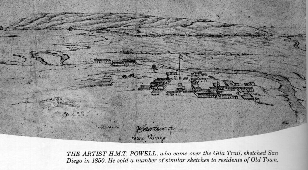
In 1850, an artist, H.M.T.
Powell, sketched San Diego Old Town showing that the Presidio
was no longer on the hill. Powell slept in wagons and sold sketches
and maps of San Diego for eight dollars to keep him alive. The
arrival of so many settlers at that time set off a land boom,
especially at La Playa which was the site of the old hide houses
and ship anchorage, and Powell was kept busy preparing maps and
site sketches. By March 9th he had earned enough money to depart
for the gold fields and left San Diego saying, "I hope forever."
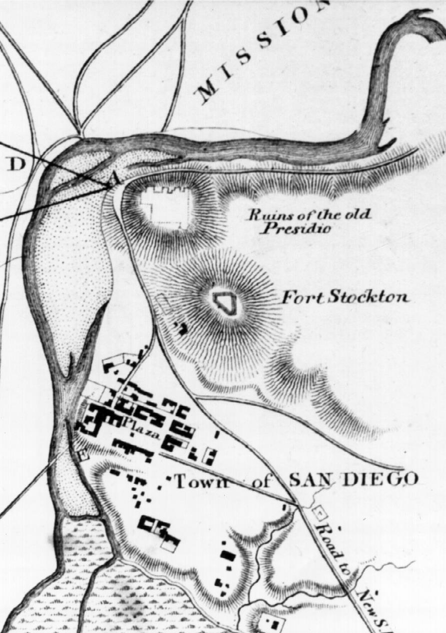
Lieutenant George Derby
of the U.S. Topographical Engineers makes the next record of the
Presidio on the Hill. A map drawn by him in 1853 as a part of
the survey of the San Diego River preliminary to relocating it
to its present bed, which empties into "False Bay" shows
an outline of the remains of the Presidio at that time.
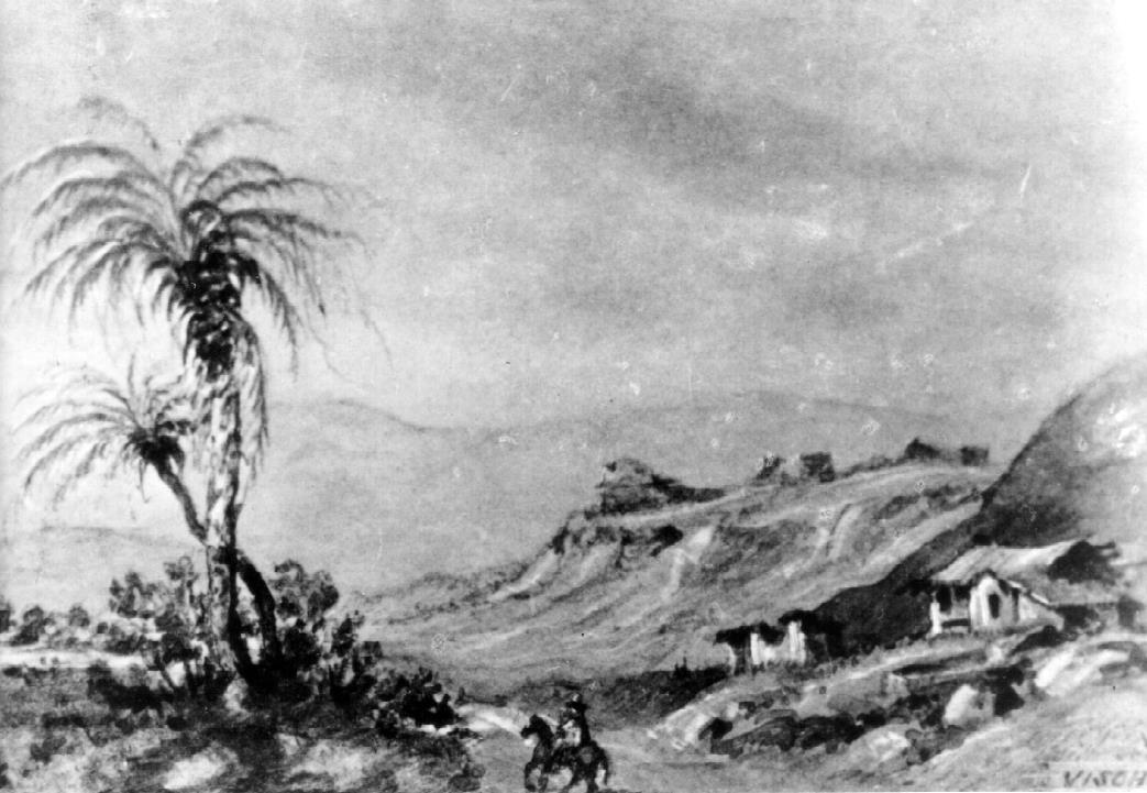
Twenty-one years later,
in 1874, another itinerant artist named Eduard M. Vischer drew
the remains of the presidio showing the collapsed condition of
the original structures. His drawings are archived at the Bancroft
Library in Berkeley, California. At that time several photographs
were also taken of the same hill from another direction showing
the bare nature of the hill, some of which had been removed to
build the dike for the new river channel. These photographs are
archived at the San Diego Historical Society in Balboa Park.
About 1850 all the land
of the Presidio, Fort Stockton and the site of the old palm tree
on Taylor Street were subdivided into square blocks and straight
streets, in the best American style without regard to hills or
canyons. For another sixty years it was in the hands of various
owners, one of whom had the grace to plant some olive trees. In
twenty years, 1909-1929, all these separate pieces of property
comprising twenty acres had been acquired by one person for the
purpose of preserving the historic ground, which has been called
" the Plymouth Rock of the Pacific". In 1927, the City
of San Diego passed an ordinance by which the streets of this
part of Old Town were vacated and the work of restoring the site
was begun. A survey of the ruins was made in 1929 resulting in
the "Broel" map on file at the San Diego Historical
Society. The ruins of the Presidio were covered carefully with
earth so the rolling knolls of grass seen today in Presidio Park
are the ruins of the Presidio. The whole area was designated as
the Presidio Park with the centerpiece being the Junipero Serra
Museum at the top of the hill. A cross made of the bricks from
the Presidio had been erected in 1913 by the Order of Panama on
the site of the comandante's house. This whole facility was dedicated
with much pomp and notoriety on July 16, 1929, the 160th anniversary
of the founding of the City of San Diego. The park is California
Historical Landmark #59 and is also listed in the National Register.
While much has been said
about the Presidio in the above historical testimony, there was
no known drawing of just what the Presidio actually looked like
either in California or in the Archives of the Indies in Seville,
Spain. Plans were known to exist for the other presidios in Alta
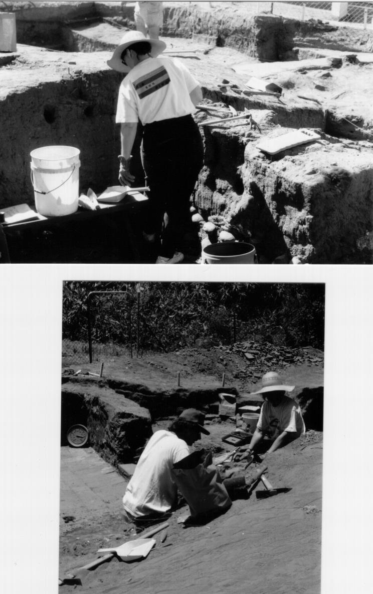
California. To shed some light on this mystery, excavations were
started to see what the ruins could tell us. From 1965 to 1976,
a "dig" was conducted by San Diego State University's
Department of Anthropology. A second "dig" was conducted
by the San Diego Mesa College from 1976 to 1986.
From these activities much
was learned about the actual shape and location of buildings and
walls. Then in 1982 plans of the four presidios in Alta California
were found by Father Harry Morrison, a priest at Saint Joseph's
Catholic Church in Pinole, California while perusing the papers
of Eduard Vischer at the Bancroft Library. All four plans were
drawn by General Mariano Guadalupe Vallejo and dated 1820. These
were first described by Richard S. Whitehead in "Alta California's
Four Fortresses," Southern California Quarterly, LXV (Spring,
1983), pp. 67-94. This newly discovered plan was compared by Greta
and Paul Ezell to the information compiled from the years of excavation
to determine just how similar it was to the research data.
The Vallejo presidio plan
was apparently what he assumed it to have been ten years before
he first visited it for a few days in late January 1830 and twelve
years before his three longer sojourns in San Diego scattered
through 1832 and early 1833.
Some of the descriptions
on the drawing agree with excavation data and some do not. The
height of the walls is given as 20 feet but none of the other
presidios are any higher than 11 feet. It is not likely that a
secondary presidio like San Diego would have higher walls than
a primary fortification like Monterey. The plan is curiously like
the other three plans in that all the shapes are a simple square,
when history tells us that the presidios had bastions. So it is
not yet clear just how much the Vallejo plan can help the archaeologists.
However the presidio concept to date is a composite plan, which
results from history, excavations and some of the aspects of the
Vallejo plan. This concept has been drawn by Jack S. Williams
and shown as a wall mural at the Junipero Serra Museum and in
A Walking Tour and Brief History of the Royal Presidio of San
Diego, 1993, by Williams. This concept includes bastions and a
raised battery of four cannon on the northwest corner of the Presidio.
The chapel is in the south wall with the entrance facing west
instead of north as in the Vallejo plan. The comandante's house
is on a mound in the middle of the parade ground with a stone
staircase from the grounds to the entrance. A guardhouse and jail
are located on the west wall next to the gate to the Presidio.
There is no "Casa Mata" as in the Vallejo plan.
These drawings are the records
of the history of the Presidio today. However, tangible artifacts
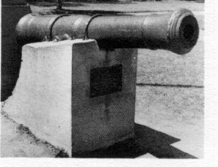
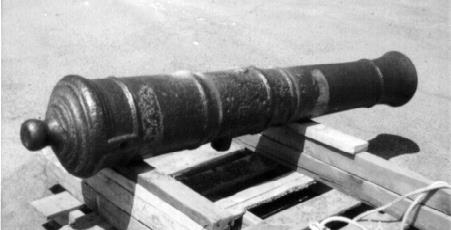
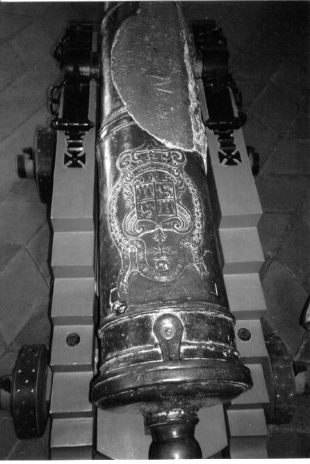
from that period are present today in the form of two cannon.
The one is called "El Jupiter" a brass 8-pounder cannon
cast in Manila in 1784 and showing the Spanish royal crest on
the barrel above the trunnions. This cannon had burst in the late
1800s due to overloading with gunpowder during a celebration and
has been repaired with a lead patch. The other cannon called "El
Capitan" is an iron 6-pounder showing a faint royal crest
on the barrel above the trunnions but not as clear as the former.
According to the San Diego
Historical Society records, both cannon were brought from Fort
Guijarros in 1838 during the political strife with Los Angeles.
For years, " El Capitan" stood upright in the Old Town
Plaza, muzzle down in the earth and was irreverently used as a
hitching post for horses and as a whipping post for naughty Native
Americans.
"El Jupiter" was
mounted on a field carriage and also stood in the Old Town Plaza
for years. It was moved to Presidio Hill in 1929. In 1981 it was
located at Fort Stockton where it was set in a block of concrete.
In 1996, it was moved to the Junipero Serra Museum and mounted
on a Spanish garrison carriage of the period.
"El Capitan" was
removed from the ground and mounted on a field carriage at some
point. In the 1960s. It is shown mounted near the Plaza on a concrete
pedestal. In 1981 it was stored in the Park Service warehouse.
In 1995, the Park Service had the barrel moved to Sacramento and
mounted it on an oak garrison carriage. It was displayed in the
Park Service offices for a number of years and then moved to the
flagpole in the plaza. San Diego Cannoneer Wayne Kenaston Jr.
and the author were the moving force to get this cannon remounted.
It is strongly recommended that "El Capitan" be moved
to the Junipero Serra Museum for display and preservation along
with "El Jupiter" instead of being left to the elements
and tourists in the Plaza.
References:
The following documents were used for references and excerpted
in the foregoing history of the San Diego Presidio: The Explorers,
The Time of the Bells, and the Silver Dons by Richard F. Pourade;
The Spanish Borderlands Frontier-1513-1821 by John Francis Bannon;
The Presidio by Max L. Moorhead; A Walking Tour and Brief History
of the Royal Presidio of San Diego by Jack S. Williams; Vallejo's
Plan of the San Diego Presidio by Greta and Paul Ezell and The
Journal of San Diego History, Volume XXXII Summer 1986, Number
3;Antigua California by Harry W. Crosby.
The Drawing
of the San Diego Presidio dated 1820.
Located in the Papers of Edward Vischer at the Bancroft Library
at Berkeley, California in 1982 by Father Harry Morrison, a priest
at Saint Joseph's Catholic Church in Pinole.
This is believed to be the only drawing of the San Diego Presidio
Made while it was still in use.
Courtesy of the Bancroft Library, University of California, Berkeley,
California.
A
drawing of the San Diego Presidio based on written testimony
in the historic record and archeological excavations.
Located in a wall mural at the Junipero Serra Museum.
Courtesy of the San Diego Historical Society, San Diego, California.
A
schematic drawing of the San Diego Presidio.
From A Walking Tour and Brief History of the Royal Presidio
of San Diego by Jack S. Williams, 1993.
Courtesy of Dr. Jack S. Williams, San Diego, California.
A map
prepared by Lieutenant George H. Derby for the U.S. Topographical
Engineers in 1853 showing an outline of the Presidio as well
as the Old Town and Fort Stockton.
A National Archives Drawing obtained from the San Diego Historical
Society, San Diego, California (2744-1).
As
presented in The Silver Dons by Richard F. Pourade, Page
158.
Union Title Company, Historical Collection, San Diego. No. 12823.
Courtesy of the San Diego Historical Society, San Diego, California.
A
drawing of the ruins on Presidio Hill as it appeared to Artist
Edward Vischer in 1874.
Courtesy of the Bancroft Library, University of California, Berkeley,
California.
Photographs
of some of the excavation work on the Presidio conducted by the
San Diego State University's Department of Anthropology From
1965 to 1976 and by the San Diego Mesa College from 1976 to 1986.
Note fired tile floor in the lower photograph.
Courtesy of Mark Allen, Junipero Serra Museum,
San Diego Historical Society, San Diego, California.
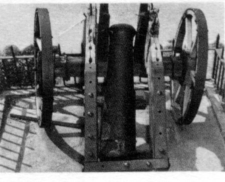
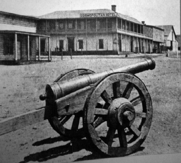
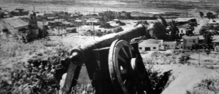
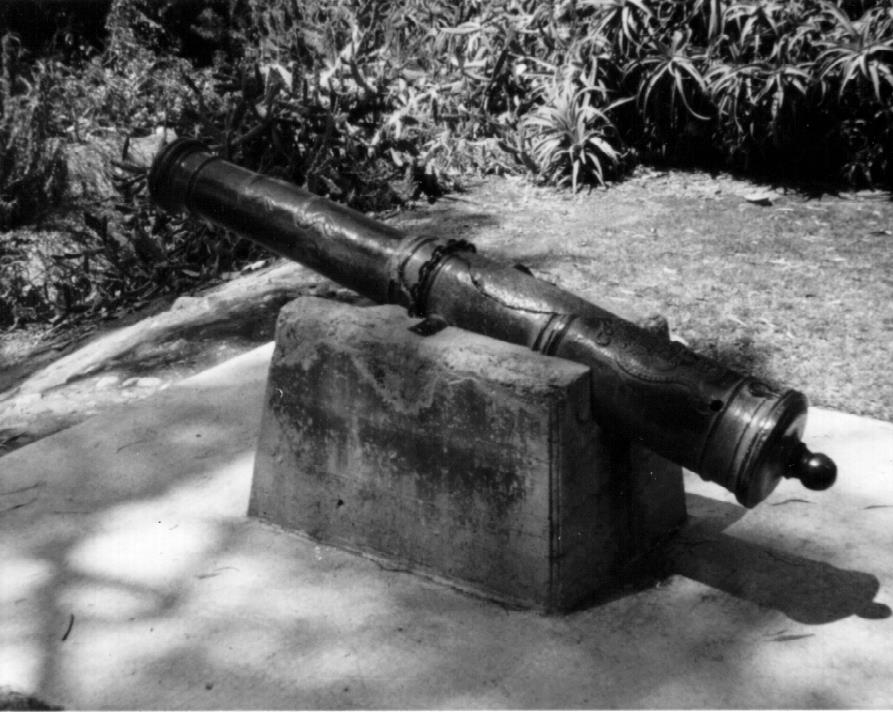
El Capitan
Displayed
in the 1960s at Old Town
Displayed
Early 1900, Site Unknown
Observed
at a State Park Warehouse in 1981
"El Capitan", an iron Six-Pounder from the Presidio
period was on display at various times and at various locations
around San Diego. Upper and middle photographs from Time of
The Bells by Richard F. Pourade, Pages 27 and 97. From the
Collection of The James S. Copley Library, LaJolla, California.
This Cannon Has a Royal Crest Above the Trunnions. Lower Photograph
by the Author.
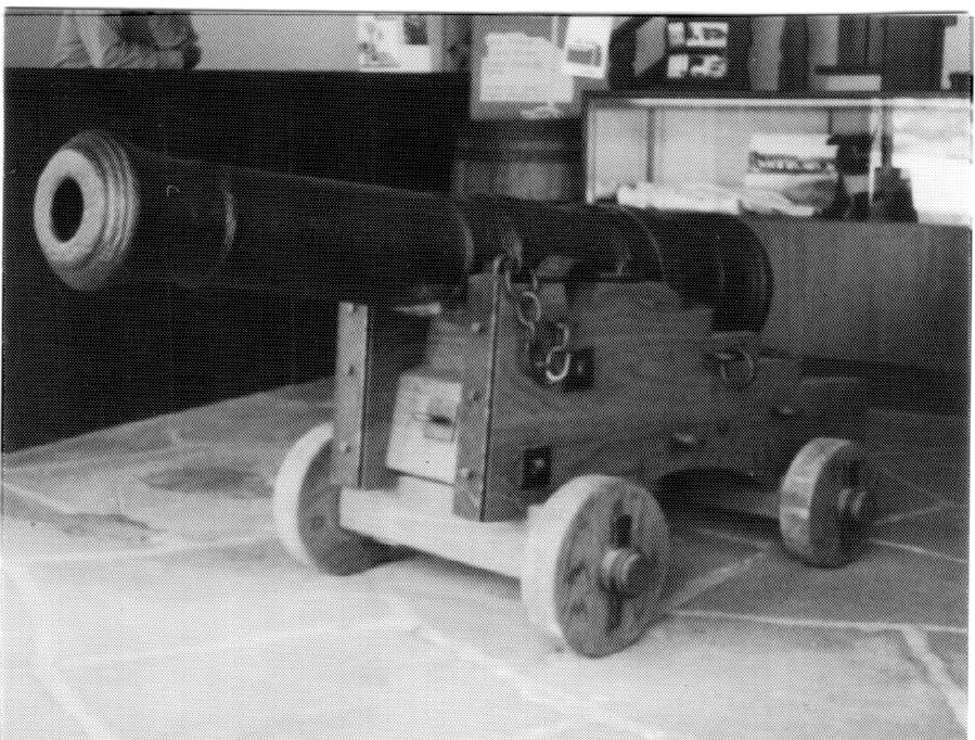
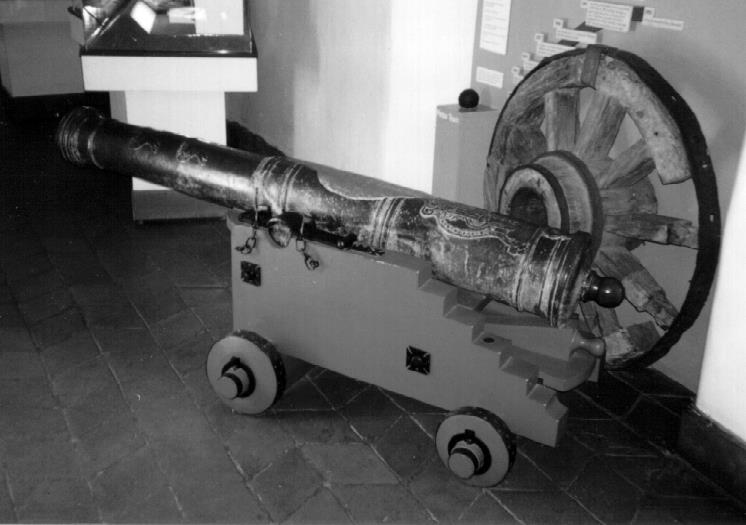
"El
Capitan" restored with a new oak carriage and hardware as
a result of a concerted effort by the California State Parks,
San Diego cannoneer Wayne Kenaston, and the author in 1995. Upper,Shown
Displayed at the Park Service Old Town Offices in 1996. Lower,
Shown Displayed at Old Town Flag Pole in 1998. Photographs by
the Author.
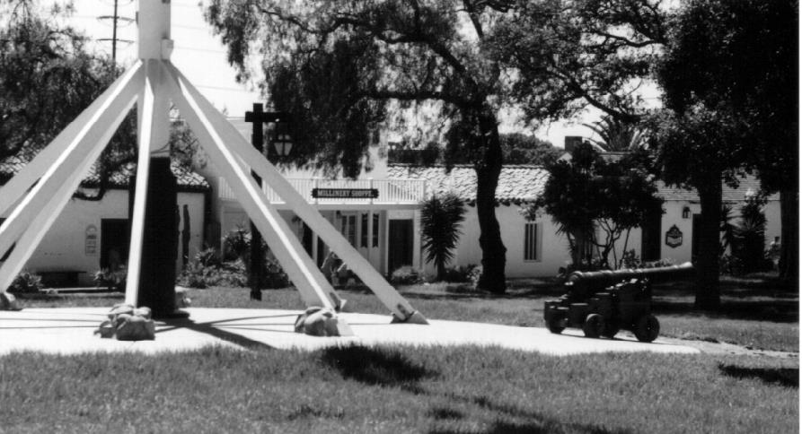
El Jupiter
Two photo
wall-murals of "El Jupiter", the brass eight-pounder.
Upper, shown in 1874 at the Old Town Plaza. Lower, " El
Jupiter" moved to Presidio Hill in 1929. Both shown mounted
on the same gun carriage but with a concrete patch on the top
to fill a burst barrel in the 1929 Image. Located at the Junipero
Serra Museum. Courtesy of the San Diego Historical Society, San
Diego, California.
"El
Jupiter" Seen Mounted Here at Fort Stockton Park in September
1981. Note Concrete Patch Above the Trunnions Photograph by the
Author.
"El
Jupiter " was moved to the Junipero Serra Museum in 1996
where it was mounted on a typical Spanish fort garrison carriage.
Shown Here in 1998. Note the oiginal wooden wheel from the earlier
carriage in the photograph on the left. Courtesy of Mark Allen,
Junipero Serra Museum, San Diego Historical Society, San Diego,
California.
From
A Walking Tour and Brief History of the Royal Presidio of
San Diego by Jack S. Williams, 1993.
Courtesy of Dr. Jack S. Williams, San Diego, California.