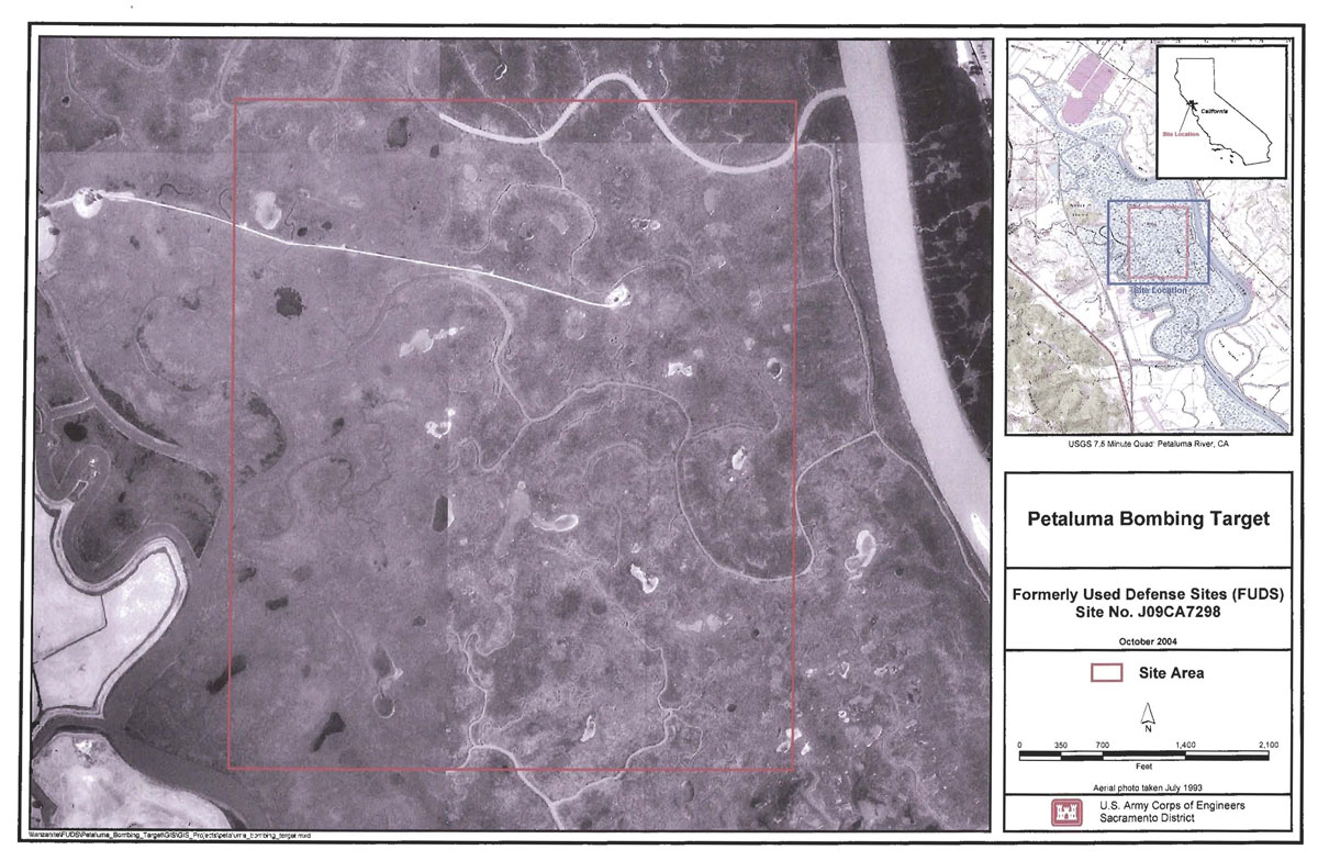
Location: The former Petaluma Bombing Target was comprised of 640 acres and located South of the town Petaluma in Sonoma County, California. The main access to the property is directly off of Highway 101 approximately one mile away from Nelis Island which is owned by the Corda family. Historical documentation lists the Petaluma Bombing Target location as Latitude 38" 11 '
and Longitude at 122" 33'.
Site History: According to a property acquisition map dated October 26, 1943, the property depicting the Petaluma Bombing Target was owned by Chester Fentress, although TechLaw was unable to obtain any deeds conveying the property to Chester Fentress. I On November 6, 1944, a Lis Pendens was filed in the District Court of California, Northern Division, to condemn an estate and interest in the southwest quarter of Section 17,southeast quarter of Section 18, northeast quarter of Section 19, and the northwest quarter of Section 20, in Township 4 North, Range 6 West of the Mount Diablo Meridian, containing 640 acres. An amendment to the Lis Pendens Civil Number 5027 was filed on Apri130, 1945, to condemn the estate to include portions of Section 17, 18, 19,20,21 and 30, of Township 4 North, Range 6 West, Mount Diablo and Meridian, Sonoma County, containing 1,770 acres. A Case Summary from the California State Lands Commission states that Charles B. Fentress and the State of California received compensation from the United States when they took possession of the 1,770 acres on Apri120, 1945.
According to a list of Gunnery Range and Target Areas released since Word War II. Twelfth Naval District, Petaluma Target No.9 was acquired by Leasehold condemnation, and superseded by leases. A letter from Naval Air Bases, Twelfth Naval District, dated January 13, 1945. discussing acquisition of required property for additional rocket training facilities, states that the lands at Petaluma should be leased for the duration and six months in the interest of and as a contribution to the successful prosecution of the war, in that a rocket range will be provided for NAAS, Santa Rosa at the Petaluma Bombing Target.
The request for deactivation of the Petaluma Bombing Target was made on August 22, 1951. due to a mid-air collision that occurred on July 18, 1950 between a Navy aircraft and an Air Force aircraft. The response to the request for deactivation occurred only after replacement locations were detennined and ready for use on 10 November 1951.
Three Leases were executed by the United States for disposal of the Petaluma Bombing Target between 1950 and 1953. The three Leases were executed between the Government as Lessee and the Petaluma Sportsman Club Noy (R) 45262 for 1680 acres; State of California Noy (R) 45263 for 90 acres; and with G. St M. Stocker and wife, covering lands in Marin County, California for an access road to the Petaluma Bombing Target. On August 16, 1978, Farm Industries, formerly Petaluma Sportsman Club, conveyed to the Califorha Department of Fish and Game 1,770 acres of land by Deed recorded in Book 3440, page 116. According to the Sonoma County Assessor's Office, the California Department of Fish and Game is the current owner of 1,770 acres, more or less, of the Petaluma Marshlands which includes the Petaluma Bombing Target and the Petaluma Rocket Range.
An undated letter from the Naval Air Bases, Twelfth Naval District, indicates that the Petaluma Bombing Target was in use by Naval Auxiliary Air Station (NAAS), Santa Rosa duning World War 11. According to the commander Air Force, Pacific Fleet, Petaluma Bombing Target contained the most highly utilized target in the San Francisco Bay Area. It was used for training by the carrier air groups based at Naval Air Station (NAS), Alameda; NAS, Moffett Field; Santa Rosa airfields; and NAS, Oakland. According to Mr. Fred Botti of the California Fish and Game, Petaluma Marshlands contains "Pannes," large circular shapes made in the ground by bombs that were dropped during practice runs.
A Memorandum requesting the deactivation of Petaluma Bombing Target was made on August 22, 1951, due to a mid-air collision over the area on July 18,1950, between a Navy aircraft and an Air Force aircraft A response to the request states that Petalurna Bombing Target will be deactivated as soon as new targets become available in the vicinity of the outlying fields, Crows Landing, California. The U.S. executed three leases for the property disposal of the Petaluma Bombing Target from 1950 to 1953. The three leases were executed between the Government as Lessee; the Petaluma Sportsman Club Noy(R)45262 for 1,680 acres; and the State of California Noy(R)45263 for 90 acres; and with G. St M. Stocker and wife, covering lands in Maria County, California for an access road to the Petaluma Rocket Range No. 9. The Leases for this property have been pursued at both the Sonoma County Recorder's oftice and at the California State Lands Commission. Neither of these sources were able to provide information regarding leases between the landowners and the U.S. government.