Historic California Posts, Camps,
Stations and Airfields
Pigeon Point Radar Site B-84
History
This Army Air Forces air defense radar
site was located at or near the Pigeon Point Lighthouse, south
of the coastal town of Pescadero in San Mateo County (37°10'53.72"N
122°23'39.65"W). Assigned to the San Francisco Control
Group, this site was operated by the 656th Signal Aircraft Warning
Company.
Radar at
Pigeon Point
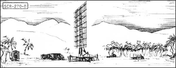
SCR-270-D Mobile Long Wave
Aircraft Warning Set
Description:
Six-vehicle mobile, long wave early warning aircraft detector.
Azimuth and range supplied. Set is equipped with "A"
scope.
Uses:
To establish a screen of warning which provides information of
approaching aircraft as early as possible but with a sacrifice
of accuracy in range, azimuth and elevation. IFF equipment RC-150
is used.
Performance and Siting: Maximum range on a single bomber flying at indicated
heights, when set is on a flat sea level site:
Altitude,
feet
1,000
5,000
20,000
25,000
Range,
miles
20
50
100
110
Set should be sited at a height
between 100' and 1000' above an unobstructed reflecting surface.
Transportability:
Complete set is carried in 6 vehicles, the largest of which measures
30'4" x 9'10" x 8'. Total weight of shipment is 101,790
lbs; total volume 11,485 cu. ft.
Installation:
Operates from trucks in which mounted. Can be placed in operation
about 6 hours after arrival at site.
Personnel: Seven
men comprise operating crew. For 24 hour operation about 50 men
are required to run radar, communication radio, and camp.
Power: 15.3
KW, supplied by PE-74, 25 KVA gasoline-driven generator, having
fixed consumption of 4 gal. per hour, non-leaded gasoline.
Search
our Site!
Questions and comments concerning
this site should be directed to the Webmaster