Historic California Posts, Camps,
Stations and Airfields
Point Sur Radar Site B-85
(Point Sur Defensive Position,
Carmel Radar Site B-85)
by Dan Sebby
Military Historian, California
Military Department
In 1942, the War Department authorized
the acquisition of land near Point Sur for use as a radar site.
It was initially known as the Point Sur Tactical Position, Harbor
Defenses of San Francisco. However, due to the secrecy surrounding
radar sites, it was common to give the sites false descriptions
that masked their true mission and actual command relationships.
Sites were often called "listening posts" or "tactical
positions." Some of these sites were also constructed to
resemble farm buildings common to the coastal regions of California
to further hide their identity. This technique continued throughout
World War II. In the War Department Owned, Leased and Sponsored
Facilities, 31 December 1945, the Site was still referred
to as part of the Harbor Defenses of San Francisco, and it was
not shown on any of the Army of the United States Station Lists
published by the Adjutant General of the U.S. Army as late as
7 May 1946. The Site was actually under the control of the Fourth
Air Force throughout World War II.
The station's primary mission was to detect
and identify all aircraft in its area of responsibility and to
direct fighter interceptors to targets deemed to be possible
threats.
The Site was initially garrisoned by a
detachment of the 656th Signal Aircraft Warning Company which
was subordinate to the San Francisco Provisional Control Group,
San Francisco Fighter Wing, IV Fighter Command, and Fourth Air
Force. On 1 April 1944, the San Francisco Control Group and its
subordinate Signal Aircraft Warning Companies were consolidated
under a single unit, the 411th Army Air Forces Base Unit (AAFBU).
During World War II the site was equipped with the following
radar sets:
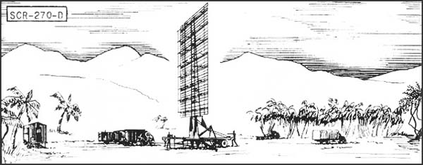
SCR-270 Mobile Long Wave Aircraft Warning
Set
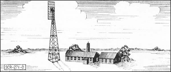
SCR-271 Fixed Long Wave Aircraft Warning
Set
SCR-516 Ground Control Interception Radar
SCR-588 Long Wave Aircraft Detector and
Ground Control Intercept Radar
In a 20 March 1946 document titled, Detailed
Plan for the Retrenchment of Fourth Air Force Control Group Installations
it was recommended that the Site be retained as an active installation.
The report also recommended that the Site assume the Identification
Friend or Foe (IFF) mission and that it be equipped it be equipped
with AN/CPS-1 or AN/CPS-5 radar sets.
On 28 February 1947, all of the air defense
radar functions on the West Coast were consolidated and Point
Sur's garrison became a detachment of Squadron "B",
412th AAFBU (Western Aircraft Control and Warning Group). The
site was inactivated on 30 June 1947,
This site consisted of two parcels approximately
15 miles south of Carmel, California, on the east side of Highway
1 and on a private ranch called the Dowd Ranch. The site was initially
was 20 acres and was reduced to 17.65 total acres. The Dowd Ranch
leased these parcels to the Army for one dollar per year.
Buildings on the site were the typical wood
framed "Theater of Operations" type with selected operational
buildings incorporating concrete fortification. Research has not
determined the specific defensive armament of the Site, but it
was typical for site like this to be defended soldiers equipped
with small arms and light machine guns for perimeter defense and
.50 caliber machine guns.
Ms. Susanna Danner, Conservation Project
Manager for the Big Sur Land Trust is familiar with the site and
has stated that there are remnants of concrete "bunkers"
on the site. Parcel one of 10 acres was located between Joshua
and Dowd Creeks while the second parcel was located 1,000 feet
north of Granite Canyon. The Corps of Engineers Warning Notice
dated 7 July 1947, states that the station was declared surplus
to the needs of the Army effective 30 June 1947. By 31 March 1948,
all equipment had been removed by the newly formed U.S. Air Force
and the post was turned over to the Army Corps of Engineers for
disposal.
Realty Control File Summary (Eng Form 1603),
states that the property was leased under number W-3460-ENG-3979
and that the station consisted of 25 buildings that were sold
on 16 December 1948. The lease was terminated 30 September 1949.
Radar Sets Used at Point Sur
SCR-270-D Mobile Long Wave
Aircraft Warning Set
Description:
Six-vehicle mobile, long wave early warning aircraft detector.
Azimuth and range supplied. Set is equipped with "A"
scope.
Uses:
To establish a screen of warning which provides information of
approaching aircraft as early as possible but with a sacrifice
of accuracy in range, azimuth and elevation. IFF equipment RC-150
is used.
Performance and Siting: Maximum range on a single bomber flying at indicated
heights, when set is on a flat sea level site:
Altitude, feet
1000
5000
20,000
25,000
Range, miles
20
50
100
110
Set should be sited at a height between
100' and 1000' above an unobstructed reflecting surface.
Transportability:
Complete set is carried in 6 vehicles, the largest of which measures
30'4" x 9'10" x 8'. Total weight of shipment is 101,790
lbs; total volume 11,485 cu. ft.
Installation:
Operates from trucks in which mounted. Can be placed in operation
about 6 hours after arrival at site.
Personnel: Seven
men comprise operating crew. For 24 hour operation about 50 men
are required to run radar, communication radio, and camp.
Power: 15.3
KW, supplied by PE-74, 25 KVA gasoline-driven generator, having
fixed consumption of 4 gal. per hour, non-leaded gasoline.
SCR-271-D and SCR-271-E Fixed
Long Wave Aircraft Warning Set
Description: Fixed
long wave early warning aircraft detector. Azimuth and range
supplied on "A" scopes. 271-D has a 100' tower; 271-E,
a 50' tower.
Uses: To
establish a screen of warning which gives data on aircraft as
early as possible, but with a sacrifice of accuracy in range,
azimuth and elevation. IFF equipment RC-151 is used.
Performance and Siting: Maximum range on a single medium bomber flying
at indicated altitudes, when set is on a flat sea level site:
Altitude, feet
1000
5000
20,000
25,000
SCR-271-E Range, miles
20
50
100
110
SCR-271-D Range, miles
25
60
120
135
Sets should be sited so that the mean
antenna height is between 100 and 1000 ft. above an unobstructed
flat surface. The 100' tower should be used when it is desired
to get additional low coverage, or to insure clearance above
surrounding trees or other obstructions.
Transportability: Sets are packed in 106 units, weighing a total
of 42,279 lbs. Largest unit is 176" x 25" x 20".
Total volume is 4008 cu. fit.
Installation: Requires
a weatherproof building approx. 20' x 40' for housing radar components
and a building approx. 20' x 20' for housing the power units
and switchboard. A 100 foot tower on concrete footings is required
for an SCR-271-D and a 50-ft. tower for an SCR-271-3. Buildings
and tower are built by engineers in about 3 weeks. Radar can
be installed by five men in about two weeks.
Personnel: 7
men are operating crew. For 24 hour operations, about 50 men
are required for radar, communication radio, and camp.
Power: 15.3
KW supplied by PE 74, 25 KVA gasoline-driven generator. Consumption
is 4 gal. per hour, non-leaded standard commercial gas.
SCR-588 Long Wave Aircraft
Detector and Ground Control Intercept Radar
Description:
Fixed medium-range, long wave aircraft detector and GCI. Provides
azimuth, range, and altitude data. Type HR and PPI scopes.
Uses:
To give continuous plan position and accurate relative height
of enemy plane and friendly fighter plane for GCI. Set can also
be used for early warning and to give increased coverage at low
angles of search. IFF equipment RC-188 is used. When operating
as GCI, VHF equipment SCR-624 is required.
Performance and Siting: Maximum range on a medium bomber, with set on flat
sea level site:
Altitude,
feet
1,000
5,000
10,000
25,000
Range*,
miles
20
50
95
105
*Range of PPI limits GCI operation
to about 45 miles.
When operating as GCI, set must be sited
so that a flat unobstructed surface extends at least 1/4th mile
in the height-finding sector. Good GCI sites are extremely rare.
For early warning, sets should be sited between 100 and 1,000
feet above an unobstructed surface.
Transportability:
Set is packaged for shipment in 55 units, weighing a total of
54,000 lbs. Largest unit measures 15.3' x 3.8' x 1.8'. Total
shipping space is 3500 cu. ft.
Installation:
Requires a weatherproof building approximately 20' x 40' for
housing radar components and a building approximately 20' x 20'
for power units and switchboard. A 25' tower on concrete footing
is required for support of antenna. Buildings and tower can be
built by Engineers in about 3 weeks. Radar can be installed by
5 men in 2 weeks.
Personnel:
8 men are operating crew. For 24-hour operation about 54 men
are required to run radar, communication radio, and camp.
Power:
4 KW at 230 volts and 1 KW at 115 volts, from three PE-198 electric
diesel units, supplied with set. (Two units operate simultaneously).
Fuel consumption is 21/2 gals. of Diesel fuel oil per hour.
AN/CPS-1 Air Transportable; Microwave
Early Warning Radar
Manufacturer: General Electric
IEEE Band: S Band
NATO Band: F Band
Exact Frequency: 3200 MHz
Maximum Instrumented Range: 200 miles
Power Required: 23 kw from portable generator
Antenna Weight: 5 tons
Scanning Rate: 10 rpm
Notes: Complete
installation weighs 66 tons. When it is necessary to make it mobile,
10 trucks are required for MEW gear and 6 more for VHF installation.
Ready for travel in 1.5 days.
AN/CPS-5 Air Transportable Ground
Control Interception Radar
Manufacturer: General Electric & Bendix
IEEE Band: L Band
NATO Band: D Band
Exact Frequency: 1300 MHz
Pulse Repetition Frequency: 400 pps
Pulse Width: 2 microseconds
Peak Power: 750 kilowatts
Maximum Instrumented Range: 60 miles (in operation aircraft
were picked up as far as 210 miles)
Maximum Altitude: 40,000 feet
System Weight: 40,000 pounds
Operators: Five men required: PPI operator, A-Scan operator,
Plotter teller, Recorder and radar repairman
Notes:
Production began January 1945. Used with AN/TPS-10.
Search
our Site!
Questions and comments concerning
this site should be directed to the Webmaster