Historic California Posts, Camps,
Stations and Airfields
Point Reyes Headland Radar Site
(SCR-682 Radar Set No. 1, Harbor
Defenses of San Francisco)
US Army Corps
of Engineers Sacramento District History (Corrected) (1993)
On 7 May 1943, the War Department acquired 1.00 permit acre from
the U.S. Coast Guard, then under the Navy Department. The total
acreage acquired was 1.00.
The site was known as Point Reyes Lighthouse
and as Point Reyes Lighthouse Reservation, CA. The actual radar
site was known ar Seacoast Radar No. 1, Harbor Defenses of San
Francisco. The site provided data for the detection and targeting
of potential seaborne threats. The site was equped with the SCR-682
Transportable Microwave Seacoast Artillery (Radar) Set. Defensive
armament consited of two M2 .50 caliber Machine Guns, one to
the west of the radar set and the other to the east.
It was situated 30 miles northwest of
San Francisco in Marin County. Improvements were not listed in
historical documents.
On 26 September 1952, 1.00 permit acre
was relinquished to the Department of Treasury. (All information
above was compiled from the real estate map of the site, below.)
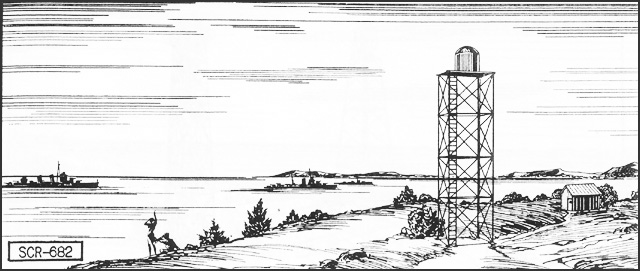
SCR-682 Transportable
Microwave Seacoast Artillery Set
Uses:
Used by 155-mm and 8-inch railway battalions. PPI gives indication
of surface craft and low-flying planes. Uses IFF (Identification
Friend or Foe) RC-282.
Performance and Siting: Set covers 360°. For a height of 100 feet,
range will average 50,000 yards or greater. At times, under favorable
conditions, very much greater maximum ranges will be achieved
from sufficient heights of site. Minimum range is about 500 yards.
Azimuth accuracy is on the order of ± 2 degrees depending
somewhat on the range scale in use. The range accuracy thus may
be considered ± 3 per cent of the range scale in use.
The range scales are 10,000; 4,000p; 160,000; and 320,000 yards.
Set should be sited not less than thirty feet above the surrounding
terrain and preferably at least 100 feet above sea level. The
optimum height of site is between 150 and 500 feet.
Transportability:
A transportable version of the SCR-582, the SCR-682 can be carried
in two standard 2-1/2-ton 6x6 cargo trucks.
Installation:
Set normally is operated form a portable tower furnished with
set. The operating components are located near the tower in a
Shelter HO-17 or housing constructed by the using troops from
materials obtained locally. No transportation is furnished with
the set.
Personnel: One
man operates the set and another plots the position of detected
targets. These men relieve one another every thirty minutes to
reduce fatigue. For 24-hour operation a chief of section, five
operators, two power plant operators, and one maintenance man
are required.
Power:
Requires about 1.28 KW, 120 V, 60 cycles, single phase.
Report of
Completed Works - Seacoast Fortifications