USAF Air Combat Command
June, 1997
The former Tecate Gap Filler Annex is located approximately 28 miles east of San Diego, and about 3/4 mile north of the international border in San Diego County, California. The US Air Force (USAF) acquired 0.59 acres of land (general use land permit) for the site complex and access to an additional approximate 9 acres of land by sublease (joint-use agreement) from the Bureau of Land Management (BLM) and the California Division of Forestry (CDF) dated 19 March 1958. An additional approximate area of 9 acres was acquired by permit (joint-use agreement) for access roadways, from private individuals in 1956 and 1957.
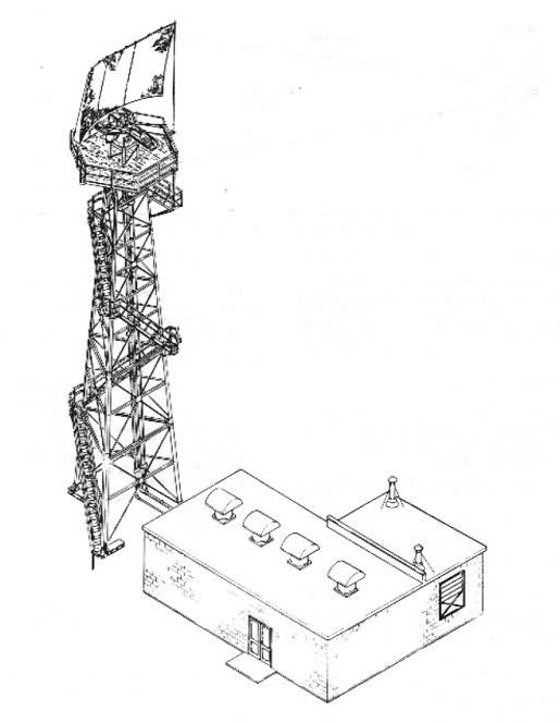
During the period of USAF control, the site was known as the Tecate Gap Filler Annex (P-76A). The site was used by the USAF as an unmanned gap filler radar annex. USAF improvements include a main building, liquid fuel pump station, Navaid tower, sanitary latrine, three underground 16,023 gallon fuel oil tanks, fencing and concrete walkways. Apparently, the site was also under the control of the CDF during the period of USAF use. Reference to joint possession was noted in a letter from the USAF to the BLM dated 8 October 1965, regarding transfer and acceptance of the property. According to BLM personnel, the California Highway Patrol (CHP) partially cleaned up the site and made some improvements approximately eight years ago. The CHP installed solai panels on the roof of the main building, a backup, above ground, propane tank, and a radio tower at the sites. In addition, CHP did some concrete work and improved the security fencing.
The site was declared excess to the requirements of the USAF on 21 February 1961 and transferred to the BLM. The transfer included all of the USAF improvements listed above, and joint use easement permits for access roadways. The transfer is contained in the letter dated 8 October 1965, and letter of acceptance from the BLM to the USAF dated 21: October 1965. According to the 8 October 1965 letter, the properties had been screened within the USAF with negative results. The transfer agreement declared the lands to be uncontaminated and considered free of all harmful substances, and contained a stipulation that BLM waive all demands for the removal of improvements and restoration of lands. At the present time, the property is under the control of the BLM. The site is used by government agencies (federal, state, local) as a communication station. According to BLM personnel familiar with the site, users include the CHP, CDF, CalTrans, US Customs, Immigration and Naturalization Service, San Diego County, and the BLM. All of the users of the communication station have a cooperative agreement with the BLM for their use of the facility and access roads. The site was apparently maintained by the CDF after the USAF departed. The forest service operated a fire lookout station at the peak. A few years ago, maintenance of the site reverted back to the BLM.
US Army Corps of Engineers Los Angeles District History (1993)
Site History: The Air Force acquired, during the years 1956 through 1958, 0.59 acres of land for the site complex and access to an additional approximate 18 acres of land (joint use) from the Bureau of Land Management (BLM), California Division of Forestry (CDF), and private individuals. The site was used by the Air Force as an unmanned gap filler radar annex. Improvements include a main building, a liquid fuel pump station, Navaid tower, sanitary latrine, three underground 16,023 gallon fuel oil tanks, fencing and concrete walkways. The site was declared surplus by the Air Force in 1961, and transferred to and accepted by the BLM in 1965.
Apparently the site was also under the control of the CDF during the period of use by the Air Force. The CDF operated a fire lookout station at the peak. After the Air Force departed, the site was maintained by the CDF. According to BLM personnel, the California Highway Patrol (CHP) partially cleaned up the site and installed solar panels on the roof of the main building, a backup aboveground propane tank, and a radio tower approximately eight years ago. In addition, the CHP did some concrete work and improved the security fencing. The maintenance of the site reverted back to the BLM a few years ago. BLM personnel indicate that current users include the CHP, CDF, CalTrans, the US Customs, the Immigration and Naturalization Service, and San Diego County. All of the users of the communication station have a cooperative agreement with the BLM for their use of the facility and access roads.
In early 1993, Tecate Peak was placed on the National Historic Register as a Cultural resource site. The peak is a spiritual place of worship for the Kuchamaa Indians. As such, the BLM plans to remove all existing structures and restore the site within the next five years.