NAF Thermal History by M.L. Shettle
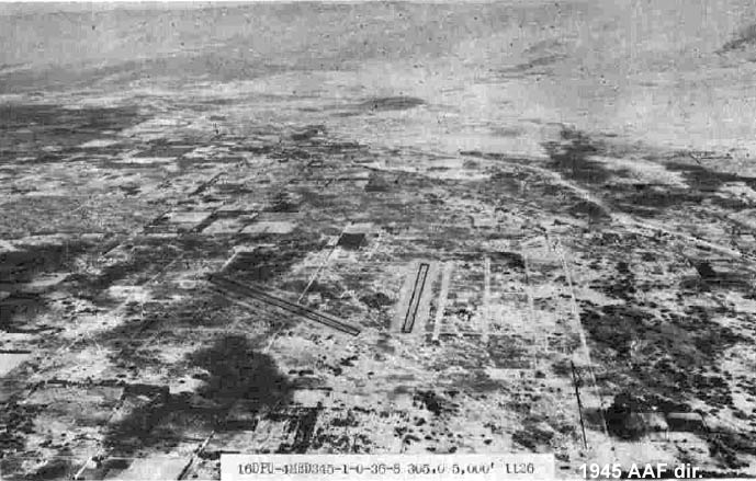
During the first year of U.S. involvement in World War II, the Army hurriedly established a training center in the California desert, 25 miles southwest of Palm Springs. General George Patton trained his army here in preparation for Operation Torch -- the invasion of North Africa. Known as Thermal Ground Support Base, the 2553-acre facility had two 5,000 ft. runways. Between March 1943, and May 1944, the Army attached several liaison and tactical reconnaissance squadrons to the airfield. Thermal had been inactive for six months when the Navy requested permission to occupy the base on December 2, 1944. Things were done quickly in those days and the Army gave verbal approval five days later. ACORN 29 and CASU II arrived aboard on December 7, and began readying the station. On December 12, the Commanding General, 4th Air Force gave the Navy official authorization to take over the airfield with the stipulation that the Army could reoccupy with 30-days notice.
Initially known as Naval Air Bases Detachment Thermal, elements of CAG 98 arrived in late December and flight operations began. Besides flying operations, the station also served as a pre-embarkation training center for ACORNS, CASUs, and Seabee units. The Navy officially commissioned NAF Thermal on February 1, 1945. A Ferry Service Unit was established for use by VRF-3. CASU 70, the last CASU created during the war, commissioned in March to support CAG 98.
The base's facilities were in rather poor condition. During the first few months of the Navy's occupancy, the ACORNS and Seabees made extensive improvements. Spread over four miles of desert, the usual Army tarpaper shacks were repaired and brought up to "Navy standards." The runways and taxiways had to be repaired and additional aircraft parking ramps installed. The Navy leased a recreation center, 2.5 miles from the base, with a swimming pool and dance hall for enlisted men. In addition, a local citizen supplied a house and swimming pool at a nearby ranch to the Navy. The house became the Commanding Officer's residence. Officers and their wives were allowed to used the pool. The ACORN, CASU, and Seabee training program ended on April 20, 1945, after ten such units had passed through the station.
CAG 98 was an operational training unit that administered refresher training -- similar to the East Coast's CAG 97. CAG 98 also maintained units at Los Alamitos and Ventura. Activity of CAG 98 peaked between June and September 1945, when 375 pilots received rocket, gunnery, and bombing training. Aircraft strength reached 115 including the F6F, F4U, TBM, SB2C, and SBD. Station aircraft consisted of a J4F, an N2S, an NE, and a GB.
Located in the Coachella Valley 150 feet below sea level, the place was named Thermal for a reason. Daily summer temperatures reached 120F in the shade soaring much higher on the concrete ramp. Conducting training here was not easy and summer flight operations took place from 0300 to 1300. In the heat of the day, the ground crews simply could not service the aircraft. At those temperatures, just touching hot aluminum would blister the skin!
Thermal Army Air Field was originally used as an air support command base under jurisdiction of the 4th Air Force, San Francisco, California. It was later occupied by the 11th Naval District by virtue of a permit drawn by the Division Engineer, South Pacific Division, dated 7 December 1944. This permit expired 15 March 1946. The 11th Naval District reports an estimated expenditure of $109,000, for alterations and additions during their period of occupancy, but descriptions of the alterations and additions are not specified. In addition to the $109,000 of alterations and additions, the War Assets Adminisration (WAA) SPB-5 Report specifically lists miscellaneous buildings, sheds, and Quonset huts as Navy improvements totaling an estimated cost of $24,932. The airfield had a maximum capacity of 2,424 enlisted. men and 264 officers. A hospital was located at the facility and had a maximum capacity of 119 patients, 68 nurses, 13 officers, and 16 enlisted men.
There were approximately 254 buildings consisting of 237 military buildings built by War and Navy Departments and 17 non-military buildings (present at the time of base acquisition). The airfield was improved with approximately 250 buildings, heating, lighting, telephone, sewer, water and power systems.
The site was declared surplus by the Army effective 16 November 1945. The Disposal Report indicates 2,554 acres were declared surplus, although Part II of the Surplus Declaration clarifies the total acreage as 2,553.43 and 1.47. The site was transferred to the WAA on 23 January 1947, including all leases, licenses, and permits except for the permanent non-transferable easement associated with tract 2-A (0.003 acres). Approximately 2,473 acres, "more or less", of the facility were transferred on 21 December 1948 to the county of Riverside via Quitclaim Deed for use as a municipal airport. Approximately 40 acres (tracts 53, 54, and 55) were deeded on 2 September 1947 to the Coachella Valley County water District. Approximately 39 acres (one-half of tract 30, tract 31, and tracts 56-61) were deeded on 20 June 1947 to the United Date Growers of California. Currently, the site is comprised of approximately 17 parcels totaling 2,549 acres estimated from parcel size) of land owned by both public and private entities. Approximately 2,285 acres of land is owned by the County of Riverside for use as a municipal airport. The balance is used for agriculture and airpark development. Approximately 188 acres (originally totaling 2,473 acres) of the property transferred from the Department of Defense to the County of Riverside was subsequently transferred to private parties. Documents regarding the transfer were not found. The railroad spur and crossing (tracts 56-61) have been removed.

.jpg)
