Historic California Posts, Camps,
Stations and Airfields
Half Moon Bay Flight Strip
(Naval Outlying Field, Half Moon
Bay)
History
by SGM Dan Sebby, Military Historian,
California Military Department
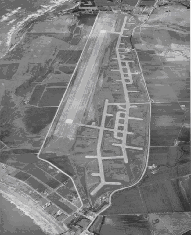
Half Moon Bay Flight Strip was authorized 15 October 1942 as
a sub-base of Salinas Army Air Base. At the same time was the
construction of a single runway on 110.33 acres of federally
owned land under the control of the Public Roads Administration
of the Federal Works Administration. Actual construction was
accomplished by the Division of Highways, California Department
of Public Works (now California Department of Transportation
or "CALTRANS") and that the lengthening of the runway
was accomplished by the Public Roads Administration and not the
US Army Corps of Engineers (USACE). Available documentation indicates
that the 110.33 acre tract was never formally transferred to
the War Department and remained under the control of the Public
Roads Administration until its conveyance to the County of San
Mateo in 1947. (War Assets Administration Property Case Files)
Half Moon Bay Flight
Strip
In November 1943, the War Department initially
acquired 11.78 acres by lease in the area known as the Half Moon
Bay Colony Subdivision. The purpose of this area has yet to be
determined, but the Station List of the Army of the United States,
published on 1 June 1943 by the Adjutant General of the U.S. Army
indicates that the Headquarters and Headquarters Company, 2nd
Battalion, 125th Infantry Regiment (Western Defense Command) and
a detachment of one of its rifle companies were in the vicinity.
From January to April 1943 the USACE began
acquiring land by purchase and condemnation proceedings in area
between the Public Road Administration's tract and State Highway
1. In this area, the USACE contracted taxiway that were connected
to the a now extended runway, protective revetments, fuel storage
and distribution systems, roadways, and administrative buildings.
When completed, the Site had a single bituminous runway measuring
5,000 feet x 150 feet, two fuel units, each capable fueling four
aircraft simultaneously, protective revetments for 23 aircraft
and billeting and messing facilities for small garrison of 56
enlisted soldiers and six officers. Available documents do not
indicate the presence of maintenance or ammunition storage facilities.
As a sub-base of the Salinas
Army Air Base, the Site would have supported that base's ground
support mission to train light observation and reconnaissance
squadrons. These would have been light aircraft and fighters modified
with camera equipment. Salinas Army Air base also had the mission
of conducting coastal patrols. As such, the Site would have been
garrisoned by a detachment of the 301st Base Headquarters and
Air Base Squadron. (armyairforces.com)
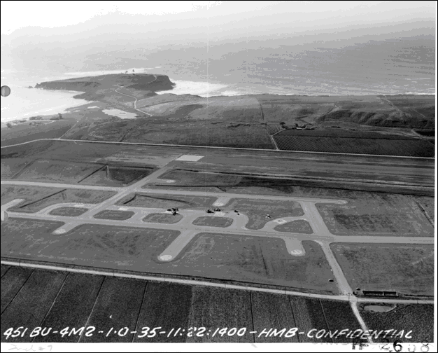
View of Half Moon Bay Flight Strip with three aircraft located
on Fueling Base No. 2. Point Pillar Military Reservation is in
the background.
With the reorganization of the Army Air
Forces that took place in the first quarter of 1944, the Site
was transferred to Air Technical Service Command and garrisoned
by its own unit, the 4159th Army Air Forces Base Unit (Air Base).
The mission of this unit was to operate the airfield for emergency
landings, transient aircraft, and training missions. Other than
refueling aircraft, no aircraft services would have been available.
At the same time as this reorganization, the War Department terminated
the leases that made up the 11.78 acre tract northwest of the
reservation. (armyairforces.com)
On 1 June 1945, the War Department issued
a five year permit to the U.S. Navy to operate the Site as "Outlying
Field, Half Moon Bay". Per Physical Properties and Facilities
of the Principal Naval Activities and Offices Located in the 12th
Naval District, dated June 1945, the Site was:
As an outlying field under Naval Air
Station Moffett Field, to furnish facilities for utility aircraft
providing target towing service for the Anti-Aircraft Training
Center, Point Montera, California.
With the end of World War II, the U.S. Navy
ended training at the Point Montera site. With that in mind, the
U.S. Navy terminated its permit with the War Department on 5 March
1946 and returned control to the War Department. The USACE in
turn declared the site excess to the needs of the U.S. Army on
1 August 1946. Custody of the 217.68 acre War Department tract
was assumed by the War Assets Administration (WAA) on 1 February
1947. Concurrent with the change of custody was the WAA's issuance
of a license to the County of San Mateo to operate a public airport
on the Site. In a letter from the Civil Aeronautics Administration
to the Chief of the Airports Division of the WAA dated 4 February
1947, the that agency is informed that the similar action was
being taken by the Public Roads Administration to allow the County
of San Mateo to use the runway pending formal transfer.
On 26 September 1947, the War Assets Administration
quitclaimed the 217.68 acre tract to the County of San Mateo.
Language in that quitclaim deed indicates that this conveyance
was done simultaneously as the Public Roads Administration's conveyance
of its 110.66 acre tract to the County of San Mateo.
Building
Inventory
Building No.
Purpose
Type of Constuction
T-1
Operations Building
& Control Tower
Theater of Operations
T-2
Pump House
Theater of Operations
T-3
Supply Building
Theater of Operations
T-4
Barracks
Theater of Operations
T-5
Latrine
Theater of Operations
T-6
Mess Hall
Theater of Operations
T-7
Bachelor Officers Quarters
Theater of Operations
T-8
Sentry Box
Theater of Operations
T-9
Barracks
Theater of Operations
T-10
Racks, Grease
Theater of Operations
T-11
Dispatch Shack
Theater of Operations
T-12
Utility Shack
Theater of Operations
T-13
Septic Tank
Not Available
T-14
Siren Tower
Not Available
T-15
Women's Air Service
Pilots Quarters
Theater of Operations
T-16
Pump House
Theater of Operations
T-17
Radio Repair
Theater of Operations
T-18
Farm House
Preexisting Structure
T-19
Barn
Preexisting Structure
T-20
Wind Indicator
Not Available
T-21
Gasoline Storage
Two 15,000-gallon steel
tanks
T-22
Gasoline Storage
21,000-gallon steel
tank
T-23
Flagpole
Wood
T-101
Shack
Theater of Operations
T-102
Shack
Theater of Operations
Source: War Assets Administration
SPB-5 Report (Appendix A)


-Point-Montara-Pilar-Point.jpg)
-Point-Montara-Pilar-Point.jpg)